Nirman Care - an educational blog

Class IX: Social Science: SA-I: Practice Paper

1. What do you understand by the term Old Regime? (1)
2 Which is the highest mountain peak of peninsular India? (1)
3 Which type of drainage pattern does an area have where hard and soft rocks exist parallel to each other? (1)
4 Which longitude is considered to be the standard meridian for Indian Standard time? (1)
5 When did the Constituent Assembly adopt the Constitution of India? (1)
6 Which was the only country till 1900 having voting right for every adult? (1)
7 What is the name given to the Parliament in China? (1)
8 What was the expenditure percentage of GDP in 1951-52 on education? (1)
9 Describe the events of 14th July 1789. (3)
10(a) What was the impact of Russian Revolution on the world? (3)
OR
10(b) Describe three problems faced by the Weimar Republic soon after its Birth.
11(a) Explain the consequences of the 1905 Revolution in Russia. (3)
OR
11(b) Explain any three methods adopted by Hitler for educating German youth in the spirit of National Socialism.
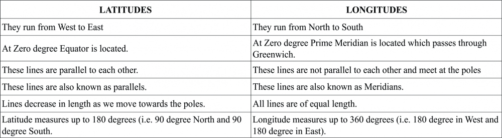
12 State the latitudinal and longitudinal extent of India's mainland. What is the Latitude of Tropic of Cancer? (3)
13 'Rivers have been of fundamental importance throughout the human history.' Justify these three points. (3)
14 Describe any three features of Shivalik range. (3)
15 Which three river systems form the Northern Plains of India? Mention main features of each. (3)
16 Mention the steps taken to curtail the power and popularity of solidarity. (3)
17 "The preamble of Indian constitution provides a Philosophy and Values of constitution." Explain any three values that you derive from it. (3)
18 "Democracy is considered the best form of government and is clearly better than any other alternative". Mention three relevant points to show what it offers. (3)
19 State the importance of growing more than one crop on a piece of land. (3)
20 Define Production. Explain the role of labour in production. (3)
21 Who constituted the middle class in French Society? How did they participate in the French Re Describe? (5)
22(a) Relate the changes which followed October Revolution in Russia. (5)
OR
22(b) Explain briefly five incidents that led to Hitler‟s Rise to Power.
23 Describe any five points of significance of Himalayas. (5)
24 Describe the struggle of the South Africa people against Apartheid. (5)
25 Define Democracy and explain its four major features. (5)
26 Describe the employment scenario in the three sectors of the economy in India in recent years. (5)
27 How are the farmers in the village Palampur able to grow more crops from the same land? Explain in five points. (5)
28 Describe five unfavourable effects of population growth in a country like India. (5)
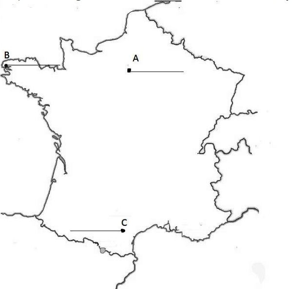
29 Three items A, B and C are shown in the given outline map of France. Identify these items with the help of following information and write their correct names on the lines marked on the map. (3)
(A) Court at the immense palace
(B) Region not affected by the Great Fear
(C) Region of Southern France was not affected by the Great Fear

30 On the given political outline map of India, locate and label the following with appropriate symbols. (3)
(X) A Northern state which shares its boundary with China and Nepal both
(Y) Lakshdweep Islands
(Z) Kolleru Lake.


-----x-----X-----x-----

Class IX: Chapter 3 (Drainage) Multiple Choice Questions:

1. When the streams flow in different directions from a central peak or dome like structure, a .......... pattern is developed.
(a) Dendritic Drainage Pattern
(b) Trellis Drainage Pattern
(c) Rectangular Drainage Pattern
(d) Radial Drainage Pattern

2. The Sutlej, Beas, Ravi, Chenab and Jhelum are the major tributaries to river .................
(a) Ganges
(b) Brahmaputra
(c) Indus
(d) Godavari

3. The river Ganga in its origin state is known as .................
(a) Alaknanda
(b) Bhagirathi
(c) Bhagirathi-Hooghly
(d) Alaknanda-Hooghly

4. .................... in Assam, is the largest riverine island formed by river Brahmaputra.
(a) Majuli
(b) Sunderban
(c) Namcha Barwa
(d) Tsangpo

5. Which river is popularly known as Dakshin Ganga?
(a) The Krishna
(b) The Godavari
(c) The Kaveri
(d) The Narmada

6. The Narmada river rises in the ....................
(a) Amarkantak
(b) Betul
(c) Nasik
(d) Mahabaleshwar

7. NRCP stands for:
(a) National River Conservation Project
(b) National River Conservation Plan
(c) National River Conversation Plan
(d) National River Conversation Plan

8. The largest salt water lake in India is known as
(a) Nainital Lake
(b) Sursagar Lake
(c) Chilika Lake
(d) Dal Lake

9. What is the total length of river Krishna?
(a) 1312 Kms
(b) 1500 Kms
(c) 1400 Kms
(d) 1250 Kms

10. The Ganga and the Brahmaputra rivers join together and forms the ..................... before submerging into the Bay of Bengal.
(a) Sunderban Delta
(b) Estuaries
(c) Water Divide
(d) Lagoons

11. In the final stage before meeting the seas and oceans, river breakup into various streams called as
(a) Tributaries
(b) Deltas
(c) Estuaries
(d) Distributaries

12. A lake formed when a meandering river is cut off from the mainstream is known as ................
(a) Ox-Bow Lakes
(b) Glacial Lakes
(c) Lagoons
(d) Man Made Lakes

13. River Brahmaputra takes a Hair Pin turn from
(a) Namcha Barwa
(b) Majuli
(c) Dihang
(d) Dibang

14. What is the total length of river Ganga?
(a) 2900 Kms
(b) 2500 Kms
(c) 2700 Kms
(d) 2300 Kms

15. The drainage basins of the peninsular rivers in comparison to the Himalayan Rivers are
(a) Smaller in Size
(b) Larger in Size
(c) Same in Size
(d) Medium in Size

16. Ambala is located on the water divide between
(a) Ganga and Brahmaputra
(b) Indus and Brahmaputra
(c) Indus and Ganga
(d) Ganga and Godavari

17. Which is NOT a common features formed by a river while flowing through plains?
(a) Flood Plains
(b) Meandering
(c) Levees
(d) Tributaries

18. The Amravati, the Bhavani, the Hemavati, the Kabini, etc. are the main tributaries of
(a) The Krishna River
(b) The Godavari River
(c) The Kaveri River
(d) The Mahanadi River

19. The Ganga Action Plan (GAP) Phase – I started in the year ..................
(a) 1984
(b) 1985
(c) 1986
(d) 1987

20. The Brahmaputra River, while flowing outside India is popularly known as .................
(a) Lohit
(b) Dihang
(c) Brahmaputra
(d) Tsangpo


-----x-----X-----x-----

Class IX: (Social Science) Extra Questions For Practice

Answer the following questions:

Q1. What do you mean by third estate general?
Q2. What is Tithes?
Q3. Write a short note on 'Tennis Court Oath'.
Q4. Write shot on intellectual cause of French Revolution.
Q5. What is Censorship?
Q6. What is a Theocracy?
Q7. Write three differences democratic and dictatorial form of government with examples.
Q8. What is the extent of coastline of India including the islands?
Q9. Distinguish between Latitudes and Longitudes (any three points).
Q10. Name all the neighboring countries of India with their locations.
Q11. Explain the importance of Standard Meridian of India.
Q12. Define Physical capital.
Q13. What are the ways to increase production in the given same piece of land?
Q14. Differentiate between Multiple cropping and Modern methods of farming.
Q15. What is meant by factors of production? Explain any two.
Q16. Map Work
(a) The northernmost and the southernmost latitude of the Indian mainland in degree.
(b) Name the southernmost point of Indian Territory.
(c) The Strait separating Sri Lanka from India
(d) Standard Meridian of India.
(e) The eastern and western most longitude in degrees


-----x-----X-----x-----

Class IX: Chapter 1 (India - Size and Location) Questions & Answers

Q1. Name the group of islands lying in the Arabian Sea & Bay of Bengal.
Ans: Lakshadweep is the group of islands located in the Arabian Sea and in the Bay of Bengal Andaman & Nicobar islands is located.

Q2. Name the countries which are larger than India.
Ans: Russia, Canada, USA, China, Brazil and Australia are the countries larger than India.

Q3. What is the size of India?
Ans: India is the seventh largest country in the world covering an area of 3.28 million square kilometers. India covers 2.4 % of the total geographical area of the world.

Q4. What is the location of India?
Ans: The mainland stretches from Latitude 8o4' North to 37o6' North and from Longitude 68o7' East to 97o25' East. The southernmost point in the Indian Territory, (in Great Nicobar Islands) is the Indira Point (6o45' North), while Kanya-kumari, is the southernmost point of Indian mainland. Tropic of Cancer crosses the country at 23o30' North dividing the country into almost two equal parts.

Q5. In which hemisphere India is located?
Ans: India is located in the Northern and Eastern hemisphere.

Q6. Distinguish between Latitudes and Longitudes.
Ans:


Q7. Which countries together make the Indian subcontinent? Name all the neighboring countries of India.
Ans: India, Bangladesh, Pakistan, Sri Lanka, Maldives, Nepal and Bhutan are the countries that together make the Indian subcontinent.
In the northwest, India shares its boundaries with Pakistan and Afghanistan. In the north, India shares its boundaries with China, Nepal and Bhutan. In the east, India shares its boundaries with Bangladesh and Myanmar. In the south, India's neighbours are Maldives and Sri Lanka. Sri Lanka is separated from India by a narrow channel of sea formed by Palk Strait.

Q8. The central location of India at the head of the Indian Ocean is considered of great significance. Why?
Ans: The central location of India at the head of the Indian Ocean is considered of great significance because of the following reasons:
(a) India is centrally located on the world map.
(b) India has longest coastline on the Indian Ocean.
(c) It is surrounded by three water bodies, in the south by the Indian Ocean, in the east by the Bay of Bengal and in the west by the Arabian Sea.
(d) India is strategically located at the centre of the trans-Indian Ocean routes which connect the European countries in the west and the countries of East Asia. Thus, India could establish close contact with West Asia, Africa and Europe from the western coast. Moreover, it could establish close contact with Southeast and East Asia from the eastern coast.
(e) Ocean sea routes, i.e., Suez Canal route, Cape of Good Hope route, pass through the Indian Ocean.
(f) India has been able to establish close cultural and commercial contacts with countries of west and east due to its central location.

Q9. Why has 82o30' E selected as standard meridian of India?
Ans:
(a) The longitudinal extent of India is 30o.
(b) The sun rises in the east and sets in the west.
(c) It takes 4 minutes for the sun to move across 1 longitude. Thus, the eastern most point of India would be 2 hours ahead of the western most point (30 x 4 = 120 minutes), in accordance with the local time.
(d) This difference in time might create confusion in air and rail timings and so many other things across the two states. To avoid this confusion a longitude passing through the midpoint of 68o7' East (western most longitude) and 97o25' East (eastern most longitude) is taken as the standard prime meridian of India (i.e. 82o30').
(e) The time at the standard meridian 82o30' which passes through Mirzapur in UP is taken as the standard time of India, followed all over the country and hence the watches show the same time in both the states (i.e. Arunachal Pradesh and Gujarat).

Q10. Map Work:
1. The island groups of India lying in the Arabian Sea and the Bay of Bengal.
2. The countries constituting Indian Subcontinent.
3. The states through which the Tropic of Cancer passes.
4. The northernmost latitude in degrees.
5. The southernmost latitude of the Indian mainland in degrees.
6. The eastern and the western most longitudes in degrees.
7. The place situated on the three seas.
8. The strait separating Sri Lanka and India.
9. The Union Territories of India.

Ans:

-----x-----X-----x-----

Class IX: Chapter 1 (India - Size and Location) Extra Questions

Q1. Differentiate between latitudes and longitudes.
Q2. What were three main characteristics of land roots to India in ancient time?
Q3. Name two union territories of western coast and one of eastern coast
Q4. What is meant by IST? Why do we need standard meridian for India? Explain?
Q5. Why do we need Standard Meridian? Where is it located? What is its significance?
Q6. Write India's size and location.
Q7. The central location of India at the head of Indian Ocean is considered as a great significance. Explain?
Q8. Why there is a difference of 2 hrs in local time between the eastern most part of Arunachal Pradesh and western most part of Gujarat?
Q9. Why do we need to form separate union territories?
Q10. Explain-
(a) Tropic of cancer
(b) Greenwich meridian
(c) Latitudes
(d) Equator

Q11. Map Skills
(a) Tropic of cancer
(b) Standard meridian of India
(c) Southernmost latitude
(d) Southern most point of mainland of India
(e) Northern most point of India
(f) Eastern most meridian
(g) Western most meridian
(h) Strait between India and Sri Lanka

Class IX: Chapter 3 - (Drainage) Extra Questions for Practice

Q1. What is a lake? How are lakes formed?

Q2. What is water pollution? Write its main sources of water pollution in Indian Rivers.

Q3. Mention 5 features of GAP1 and GAP2.

Q4. Why are lakes and rivers important for countries economy?

Q5. With the help of stable diagram explain drainage patterns.

Q6. Why rivers are considered lifelines of human civilizations? Explain any 3 reasons.

Q7. Discuss significant differences between Himalayan and Peninsular rivers.

Q8. Compare east flowing and west flowing rivers of peninsular plateau.

Q9. Write about the following:
(a) Water divide.
(b) River System.
(c) River Godavari.

Q10. Explain about the following:
(a) River Ganga.
(b) River Indus.
(c) River Brahmaputra.

Q11. Map Skills:
(i) On an outline map of India mark and label the following rivers: Ganga, Satluj, Damodar, Krishna, Narmada, Tapi, Mahanadi, and Brahmaputra.
(ii) On an outline map of India mark and label the following lakes: Chilika, Sambhar, Wular, Pulicat, Kolleru.


-----x-----X-----x-----

Newer posts → Home ← Older posts