Nirman Care - an educational blog

Class IX: Chapter 5 (Natural Vegetation & Wildlife)

Objectives and Goals:

1. Define Natural Vegetation (Virgin Vegetation).
2. Define Flora & Fauna.
3. Factors which affect the diversity of flora and fauna.
4. Define Ecosystem.
5. Biomes.
6. Types of Vegetations found in India. (Tropical Evergreen Forests, Tropical Deciduous Forests, Tropical Thorn Forests & Scrubs, Montane Forests and Mangrove Forests) .
7. Importance of Medicinal Plants.
8. Wildlife of India.
9. Threat to the Flora and Fauna.
10. Why conservation of Flora and Fauna is must?
11. Steps taken to protect the Flora and Fauna.


Natural Vegetation:
The naturally growing plant cover; without human aid; is called natural vegetation. The vegetation which has been left undisturbed by humans for a long time is called virgin vegetation.
The virgin vegetation, which are purely Indian are known as endemic or indigenous species but those which have come from outside India are termed as exotic plants.

Flora:
Plant species of a particular region or period are called flora.

Fauna:
The animal species of a particular region or period are called fauna.


Factors which Affect the Diversity of Flora and Fauna:

Relief:
1. Land: Land directly and indirectly affects the natural vegetation. Nature of land influences the type of vegetation. If the land is level and fertile, it is mainly used for farming. If the land is uneven then grassland and woodlands develop over it.

2. Soil: Different types of soil are fit for different types of vegetation. For example; sandy soil is fit for cactus and thorny bushes, while wet and marshy soil is fit for mangrove vegetation.

Climate:
1. Temperature and Humidity: Temperature and humidity are the main factors which determine the character and extent of vegetation. An area with high temperature and high humidity supports evergreen forest, while an area with high temperature and low humidity supports thorny bushes.

2. Photoperiod (Sunlight): The duration of sunlight is called photoperiod. Photoperiod depends on latitude, altitude, season and duration of the day. Trees grow faster in summer because of longer photoperiod.

3. Precipitation: If an area gets heavy rainfall, it is suitable for the growth of dense vegetation. On the other hand, an area with scanty rainfall is suitable for thorny bushes.


ECOSYSTEM:
(a) All the plants and animals in an area are interdependent on each other.
(b) The plants and animals; along with their physical environment make the ecosystem. Interrelation between plants and animals in the natural environment is called Ecosystem.
(c) A very large ecosystem is called a biome. Biomes are identified on the basis of plants.
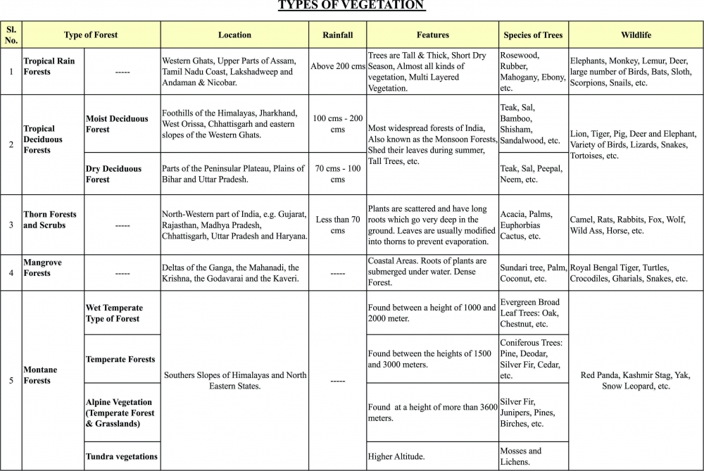
 

TYPE OF VEGETATIONS


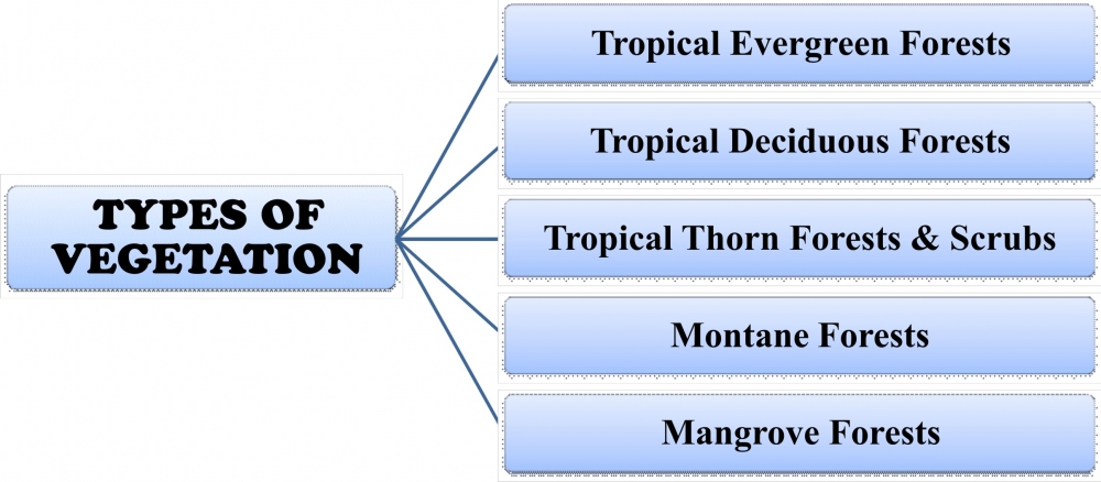
Tropical Rain Forests
(a) The tropical rainforests are confined to areas of heavy rainfall.
(b) Such areas are in the Western Ghats, upper parts of Assam, Tamil Nadu coast and the island groups of Lakshadweep and Andaman & Nicobar.
(c) Areas which receive more 200 cm of rainfall and have a short dry season are the best area for tropical rainforest.
(d) Almost all kinds of vegetation; like trees, shrubs and creepers; are found in such a forest.
(e) The forest has a multilayered structure.
(f) Ebony, mahogany, rosewood, rubber and cinchona are some of the commercially important trees of tropical rainforests.
(g) Elephants, monkey, lemur and deer are the common animals in these forests.
(h) Apart from them, a large number of birds, bats, sloth, scorpions and snails are also found in tropical rainforests.


Tropical Deciduous Forests
(a) Tropical deciduous forests are the most widespread forests of India.
(b) Spread in regions which get rainfall between 200 cm and 70 cm.
(c) They are also called the monsoon forests.
(d) The trees of tropical deciduous rainforests shed their leaves during summer.
(e) These forests can be divided into two types on the basis of availability of water:
      1. Moist Deciduous Forest:
          (i) The moist deciduous forests are found in areas which receive rainfall between 200 cm and 100 cm.
          (ii) Such forests are found mainly in the eastern part of India; like northeastern states, along the foothills of                 the Himalayas, Jharkhand, West  Orissa and Chattisgarh.
          (iii) They are also found on the eastern slopes of the Western Ghats.

      2. Dry Deciduous Forest:
          (i) The dry deciduous forests are found in those regions which receive rainfall between 100 cm and 70 cm.
          (ii) Such forests are found in the rainier parts of the peninsular plateau and the plains of Bihar and Uttar                      Pradesh.
(f) Teak, Bamboo, Sal, Shisham, Sandalwood, Khair, Kusum, Arjun, Mulberry are some of the commercially important trees in these forests.
(g) Lion, Tiger, Pig, Deer and Elephant are the common animals in these forests.
(h) Additionally, a large variety of Birds, Lizards, Snakes and Tortoises are found in these forests.


The Thorn Forests and Scrubs
(a) Thorn forests grow in those regions which receive less than 70 cm of rainfall.
(b) This type of vegetation is found in the north-western part of India, e.g. Gujarat, Rajasthan, Madhya Pradesh, Chhattisgarh, Uttar Pradesh and Haryana.
(c) The main plant species in such a forest are Acacia, Palms, Euphorbias and Cactus.
(d) The trees are scattered and they have long roots which go very deep in the ground.
(e) The stems are succulent to conserve water.
(f) Leaves are usually modified into thorns to prevent evaporation.
(g) Camel, Rats, Mice, Rabbits, Fox, Wolf, Tiger, Lion, Wild Ass, Horse, etc. are the common animals in thorny forests.


Montane Forests
The forests in the mountainous areas are called Montane forest.
Different types of vegetation are found at different altitudes in the mountains:
(a) The wet temperate type of forest is found between a height of 1000 and 2000 meter. Evergreen broad-leaf trees such as Oak and Chestnut abound in such forests.
(b) Temperate forests are found between the heights of 1500 and 3000 meters. Coniferous trees; like Pine, Deodar, Silver Fir, Spruce and Cedar abound in such forests.
(c) Alpine vegetation (temperate forest and grasslands) are found at a height of more than 3600 meters. Silver fir, Junipers, Pines and Birches are the common trees found here.
(d) Above alpine vegetations found are the shrubs and scrubs used for grazing of animals by the nomadic tribes (i.e. Gujjars and Bakarwals).
(e) At the higher altitude Tundra vegetations are found. Mosses and lichens are found here.
Kashmir Stag, Spotted Deer, Wild Sheep, Jack Rabbit, Tibetan Antelope, Yak, Snow Leopard, Squirrels, Shaggy Horn, Wild Ibex, Bear, Rare Red Panda, Sheep And Goats are the common animals in these forests.


Mangrove Forests
Mangrove forests are found in the deltas of the Ganga, the Mahanadi, the Krishna, the Godavari and the Kaveri.
(a) Roots of the mangrove plants are submerged under water.
(b) Hollow roots grow out vertically above water so that roots can breathe.
(c) Sundari tree is the most common tree in such forests; especially in the Sunderban Delta.
(d) Royal Bengal Tiger is the most famous animal of these forests.
(e) Additionally, Turtles, Crocodiles, Gharials and Snakes are found in these forests.


WILD LIFE
(a) There are more than 89,000 animal species in India.
(b) There are more than 1200 species of birds in India.
(c) Elephants are found in the hot wet forests of Assam, Karnataka and Kerala.
(d) One-horned rhinos are found in the swampy and marshy lands of Assam and West Bengal.
(e) Wild ass and camels are found in the Rann of Kachchh and Thar Desert.
(f) Indian Bison, Nilgai, Chousingha, Gazel and many other species of deer and some other animals are found in India.
(g) India is the only country in the world which has both tigers and lions.
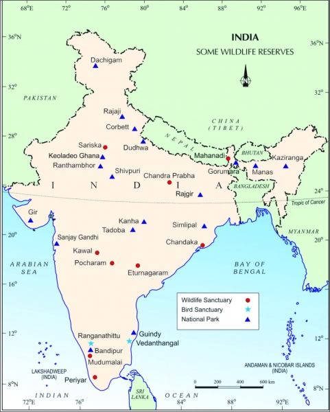
(h) There are fourteen biosphere reserves in India.
(i) Four out of these, the SUNDERBANS IN THE WEST BENGAL, NANDA DEVI IN UTTARANCHAL, the GULF OF MANNAR IN TAMIL NADU and the NILGIRIS (KERALA, KARNATAKA AND TAMIL NADU) have been included in the world network of Biosphese reserves.
(j) The fourteen biosphere reserves are: Sunderbans, Gulf of Mannar, the Nilgiris, Nanda Devi, Nokrek, Great Nicobar, Manas, Simlipal, Dihang-Dibang, Dibru Saikhowa, Agasthyamalai, Kanchenjunga, Pachmari, Achanakmar-Amarkantak..
(k) Project Tiger, Project Rhino, Project Great Indian Bustard and many other eco-developmental projects have been introduced.
(l) 89 National Parks, 49 Wildlife sanctuaries and Zoological gardens are set up to take care of Natural heritage.
(m) Wildlife Protection Act 1972.


-----x-----X-----x-----

Class IX: Geography: SA-I: Map Work

CHAPTER - 1 (INDIA - SIZE & LOCATION)

Tropic of Cancer, Standard Meridian of India, Southern most point of India, Southernmost point of Indian mainland, Northernmost point of India, Easternmost meridian of India, Westernmost Meridian of India.


CHAPTER - 2 (PHYSICAL FEATURES OF INDIA)

(a) Mt. Peaks: Mt. Everest, K2, Kanchenjunga, Nanda Devi, Anai Mudi, Mahendra Giri.
(b) Passes: Bomdi-la, Nathula, Shipkila.
(c) Hills: Garo, Khasi, Jaintia, Naga hills, Mizo hills.
(d) Mountain Ranges: The Karakoram, Zaskar, Shivaliks, Aravalli, Vindhya, Satpura, Western Ghats, Eastern Ghats.
(e) Plateaus: Deccan plateau, Chota Nagpur plateau, Malwa plateau.
(f) Coastal Strips: Coromandel, Northern Circar, Malabar, Konkan.


CHAPTER - 3 (DRAINAGE)

(a) Lakes: Chilka, Pulicat, Kolleru, Sambhar, Wular.
(b) Rivers: Indus, Ganga, Brahmaputra, Satluj, Narmada, Tapi, Mahanadi, Godavari, Krishna, Kaveri.


-----x-----X-----x-----

Class IX: Geography: SA-I: Extra Questions For Practice

CHAPTER – 1 (INDIA- SIZE AND LOCATION)

Q1. Describe the location and size of India.
Q2. Why is the difference between the duration of the day and night hardly felt in Kanyakumari but it is not so in Kashmir?
Q3. Distinguish between latitudes and Longitude.
Q4. How does India occupy an important strategic position in South Asia? Illustrate your answer by explaining three suitable points.
Q5. Which latitude and longitude divides India into two halves?
Q6. What is the latitudinal and longitudinal extent of India in degrees?
Q7. Name the canal that shortened the distance between India and Europe.
Q8. Why 82o30' East longitude (Mirzapur in Uttar Pradesh) is taken as the Standard Time Meridian of India?
Q9. Name the countries which are larger than India.
Q10. Name the two countries which are our southern neighbors.
Q11. Name the southernmost latitude of Indian Territory, which got submerged in the year 2004. Also, write its degree.


CHAPTER 2 (PHYSICAL FEATURES OF INDIA)

Q1. Mention the nature of geology and topography of the Himalayas, the Peninsular Plateau and the Northern Plains.
Q2. Why Himalayas are called the young fold mountains?
Q3. Pitti Island is located in Lakshadweep islands. Write any two features of the Pitti island.
Q4. Which island was earlier known as Laccadive, Minicoy and Amindive.
Q5. India's only active volcano is located in which part of the Andaman and Nicobar islands?
Q6. Write three important features of the Indian Desert.
Q7. What is Doab?
Q8. The Deccan Plateau extends towards the east, name the three prominent hill ranges from west to east.
Q9. Which are the two landforms that have developed most recently?
Q10. Write any five characteristics of the Great Himalayas.
Q11. Write any five characteristics of the Peninsular Plateaus.
Q12. Write any five characteristics of the Northern Plains.
Q13. Mention five characteristics of the Eastern Himalayas.
Q14. What are Duns? Give some examples.
Q15. Name the divisions of the Western Coastal Plains.
Q16. Name the divisions of the Eastern Coastal Plains.
Q17. Name the three types of plate boundaries. Write one characteristic each.
Q18. Name the three types of stress built with the plates, with a suitable example.
Q19. Write three important features of the Aravalli hills.
Q20. Name the three major divisions of the Himalayas from north to south.
Q21. Name the four major divisions of the Himalayas from west to east.
Q22. Name the group of islands having the coral origin.


CHAPTER – 3 (DRAINAGE)

Q1. Explain the formation of fresh water lake in the Himalayan region. Give an example.
Q2. Why rivers are considered lifelines of the human civilizations. Explain any three reasons.
Q3. What progress has been made in the Ganga Action Plan?
Q4. What are the major factors responsible for river pollution? Explain.
Q5. Mention any three features of Indian Drainage System.
Q6. What is the importance of lakes? or How lakes are of great value to human beings? State any five importance. or Mention some characteristics of lakes.
Q7. How does a river affect the economy of a country?
Q8. From where does the river Brahmaputra rise? Name the two tributaries of the river Brahmaputra.
Q9. In which two groups are the Indian rivers divided? Write four points to differentiate between the two.
Q10. Name the largest riverine island made by the Brahmaputra River.
Q11. Name the major tributaries of river Indus.
Q12. What are the major factors responsible for reducing the volume of water in Indian rivers?
Q13. Explain the "National River Conservation Plan" in brief.
Q14. Write five important features of the Ganga river system.
Q15. Mention a short note on the Godavari river system.
Q16. Write a note on the Peninsular Rivers.
Q17. Explain the different drainage patterns formed by the rivers.


-----x-----X-----x-----

Class IX: Social Science: SA-I: Practice Paper

1.What was the main object of National Assembly in France while drafting the constitution in 1791?
2. Which drainage pattern is formed by River Ganga?
3 .Which is the western most longitude of India?
4. Name the part of Himalaya lying between Kali and Tista rivers.
5. Pinochet rule in Chile ended after he decided to hold a referendum. In which year was referendum held?
6. When did Mexico get independence?
7.How much time did it take the Constituent Assembly to complete the Indian Constitution?
8 .What was the expenditure percentage of GDP in 1951-52 on education?
9. Describe the events of 14th July 1789.
10 (a) Who were radicals? Describe briefly.
OR
10 (b) Explain the new education policy introduced by Hitler in Germany.
11 (a) Explain any three differences between the political ideas of Liberals and Radicals in Russia during the early twentieth century.
OR
11(b) Highlight three main features of the Nazi World view?
12. India accounts for about 2.4 percent of the total geographical area of the world but supports the second largest population of the world. What are its three implications?
13. Justify the naming of Indian Ocean after India.
14. Mention any six tectonics plates of the earth's crust.
15. Name the three sections into which Northern plain has been divided. Write one feature of each.
16. How did Robert Mugabe's party ZANU PF violate the features of a democratically elected government? Mention any three methods adopted by the party.
17. ‟The Constituent Assembly worked in a systematic open and consensual manner." Mention any three values that are depicted by the Constituent Assembly.
18. Describe any three demands of the workers of "Lenin Shipyard" during their strike which started in August 1980 in Poland.
19. Describe any three ways by which production can be increased from a fixed plot of land.
20. What does a "virtuous cycle" created by the educated parents mean? Explain.
21. Explain the immediate causes of the outbreak of the revolt in France in 1789.
22 (a) Explain any five socio –economic conditions of Russia at the beginning of the twentieth century?
OR
22 (b) Hitler's foreign policy aimed at gaining power and prestige for Germany. State this features of his foreign policy.
23. Give an account of the four divisions of Himalayas from west to east along with Purvanchal hills respectively.
24. Even democracy has a fair share of demerits. Point out five such demerits.
25. Highlight the salient features of the Constitution of India.
26. Explain the meaning of "Physical Capital"? Explain its two types with the help of suitable examples.
27. Explain any five effects of unemployment in India.
28. "Green Revolution is associated with loss of soil fertility". In the light of the statement mention five problems caused by modern farming.
29. Three items A, B and C are shown in the given outline map of France. Identify these items with the help of following information and write their correct names on the lines marked on the map.
(A) Port related to slave trade.
(B) The region not affected by the great fear.
(C) The place where French revolution of 1789 started.

30. On the given political outline map of India, locate and label the following with appropriate symbols:
(X) Standard Meridian of India
(Y) Jaintia Hills
(Z) River Tapi


-----x-----X-----x-----


Class IX: Social Science: SA-I: Practice Paper

1 Who was the author of the book "The Spirit of the Laws"? (1)
2 Which is the largest river of the Peninsular Plateau? (1)
3 What do the lofty peaks represent about the age of the Himalayas? (1)
4 What is the degree of longitude of westernmost tip of India lying in Gujarat? (1)
5 Which party ruled Poland in 1980? (1)
6 When was the military coup by Pervez Musharraf held? (1)
7 Mention any two principles to which the white minority agreed to compromise for co- existence in South Africa. (1)
8 Farmer‟s plough is an example of which factor of production? (1)
9 Briefly describe the role of French philosophers in creating awareness among the people to fight for their rights? (3)
10(a) Explain Karl Marx‟s theory of Socialism. (3)
OR
10(b) Describe the suffering of Jews caused by Holocaust.
11(a) Illustrate the main events which lead to the February Revolution in Petrograd. (3)
OR
11(b) Describe briefly the early phase of Hitler‟s life.
12 Describe any three important features of the Godavari Basin. (3)
13 What was the need for selecting the standard meridian of India? Explain. (3)
14 Why is the Northern plain of India more productive agriculturally? Give three reasons. (3)
15 Why are large number of meanders found in the Northern plains of India? (3)
16 How was Poland ruled by the communist government? Give 3 features. (3)
17 "The preamble of Indian constitution provides a Philosophy and Values of constitution." Explain any three values that you derive from it. (3)
18 "Democracy leads to better decisions in comparison to non-democratic form of government‟. Give three reasons. (3)
19 How is investment in human capital similar to investment in physical capital? Mention three similarities. (3)
20 Mention any three steps taken by government to improve literacy rate in India. (3)
21 Examine the changes brought about in the life of women by the revolutionary government. (5)
22(a) New developments could be seen under Stalin in Russia in the villages. Describe these developments. (5)
OR
22(b) Which event led to Great Economic Depression ? How did it affect the German economy? Explain.
23 Name two coastal strips of the Peninsular plateau of India. Describe two characteristics of each. (5)
24 What is meant by the Apartheid ? How did the people of South Africa struggle against it? (5)
25 "Is Democracy the best form of governance‟? Support your answer with suitable arguments. (5)
26 What is the main production activity in Palampur? Explain any four non – farm activities done in this village. (5)
27 Define non farm activities. Describe any two non-farm activities practised in Palampur. (5)
28 Explain any five effects of unemployment in India. (5)
29 Three items A, B and C are shown in the given outline map of France. Identify these items with the help of following information and write their correct names on the lines marked on the map. (3)
(A) Prison storm place
(B) Epicenter of main panic movement in eastern France
(C) Epicenter of main panic movement in western France

30 On the given political outline map of India, locate and label the following with appropriate symbols. (3)
(X) Standard Meridian of India
(Y) Bomdila Pass
(Z) Chilika Lake


-----x-----X-----x-----

Newer posts → Home ← Older posts