Class IX: Chapter 2 - Physical Features of India
Objectives and Goals:
1. The Physical features of India.
2. Theory of Plate Tectonic.
3. Three types of plate boundaries (i.e. Convergent Boundary, Divergent Boundary and Transform Boundary).
4. The Continental Drift Theory.
5. Formation of India.
6. The major physiographic divisions of India (i.e. The Himalayan Mountains, The Northern Plains, The Peninsular Plateau, The Indian Desert, The Coastal Plains, and The Islands).
7. The great Himalayas, three parallel ranges in its longitudinal extent (i.e. The Great or Inner Himalayas or Himadri, The Lesser Himalaya or Himachal and The Shiwaliks).
8. Some of the highest peaks of Himalayas.
9. Division of Himalayan regions from west to east (i.e. Punjab Himalayas, Kumaon Himalayas, Nepal Himalayas and Assam Himalayas).
10. Eastern hills and mountains (i.e. Patkai Hills, Naga Hills, Manipuri Hills and Mizo Hills).
11. The Northern Plains, three sections of Northern Plain (i.e. Punjab Plains, Ganga Plains and Brahmaputra Plains).
12. Division of northern plain on the basis of relief features; divided into four regions (i.e. Bhabar, Terai, Bhangar and Khadar).
13. The Peninsular Plateau, which is broadly divided into two regions (i.e. The Central Highlands and The Deccan Plateau).
14. Western and Eastern Ghats.
15. Indian Desert.
16. Coastal Plain of India (i.e. The Eastern and Western Coastal Plains).
17. Islands of India (i.e. Lakshadweep Islands and Andaman and Nicobar Islands).
Theory of Plate Tectonics: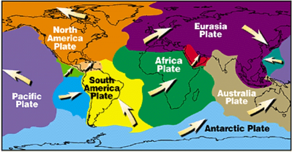
- The continental blocks or the plates are floating on mantle.
- The Crust (upper part) of the earth has been formed out of seven major and some minor plates. Following are the seven major plates: -
- African Plate
- Antarctic Plate
- Eurasian Plate
- Indo-Australian Plate
- North American Plate
- Pacific Plate
- South American Plate
They move with the change or release of pressure and temperature inside the earth.
Folding: Caused by compression, when blocks of landforms comes closer to each other, they form wrinkles or folds on the earth's surface. E.g. the young fold mountains "Himalayas".
Faulting: The structure of rocks cracks or breaks along the weaker areas due to tension, this is called faulting. This may cause upliftment and subsidence of land and can form Block Mountains. E.g. Vindhyas and Satpura hills.
When a part of land subsides between two faults, it forms Rift Valley. Narmada & Tapti Rivers flow through the rift valley.
Volcanic Activities: Natural openings in the earth's crust through which molten materials, rocks, ashes, gases, etc are thrown out are called 'Volcanoes'.
Theory of Plate Tectonics: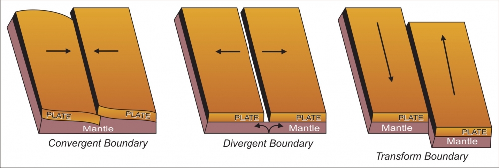
Plate movements are of three types:
1. Convergent Boundary: In this case, the two adjacent tectonic plates move towards each other.
2. Divergent Boundary: In this case, the two adjacent plates move away from each other.
3. Transform Boundary: In this case, the two adjacent plates move along their borders.
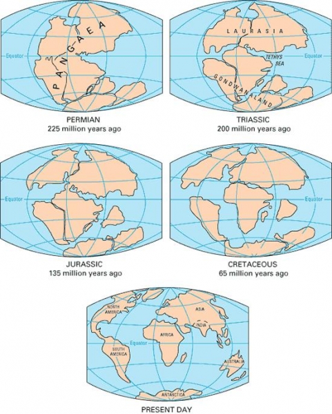
Continental Drift Theory:
- According to the theory of Continental Drift, the world was made up of a single continent through most of geologic time. That continent eventually separated and drifted apart, forming into the seven continents we have today. The first comprehensive theory of continental drift was suggested by the German meteorologist Alfred Wegener in 1912.
- Million of year also there was a single continent named "Pangaea". Pangaea broke into pieces due to internal forces and is drifting away from each other since last almost 250 million years.
- Two landmasses – "Laurasia in North" and "Gondwanaland in South".
- Both the landmasses were separated by a shallow sea called "Tethys Sea".
- Size of Tethys sea kept on decreasing due to movement of landmasses towards each other, thus, resulting in the formation of the young fold mountains "Himalayas".
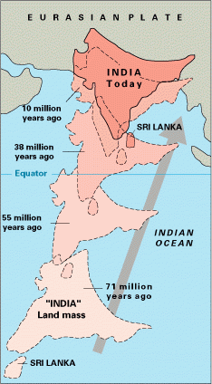 Formation of India
- The Indian Peninsula drifted towards the north and finally collided with the much larger Eurasian Plate.
- As a result of this collision, the sedimentary rocks which were accumulated in the geosynclines (known as Tethys) got folded and formed the mountain systems of the West Asia and Himalaya
- Due to the uplift of the Himalayas in the Tethys Sea, the northern part of the Indian Peninsula got subsided and formed a large basin. That basin was filled with sediments from the rivers which came from the mountains in the north and from the peninsula in the south.
- Thus, the northern plains of India came into existence. These plains are made up of alluvial deposits.
- The peninsular plateau is known as the old topography, whereas the Himalayas and the Northern plains are considered as new topography.
- The peninsular plateau is composed of igneous and metamorphic rocks with gently rising hills and wide valleys.
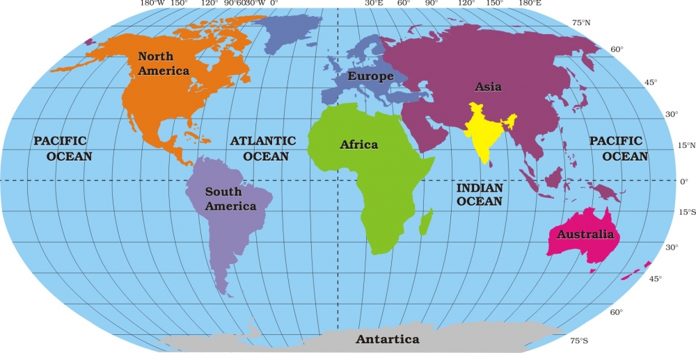
INDIA
The major physiographic divisions of India: -
1. The Himalayan Mountains
2. The Northern Plains
3. The Peninsular Plateau
4. The Indian Desert
5. The Coastal Plains
6. The Islands
1. THE HIMALAYAN MOUNTAINS
- The name "Himalaya" means "the abode or house of snow" in Sanskrit (i.e. hima "snow", and ālaya "abode or house".
- The Himalaya mountain range is the highest on earth and is often referred to as the "roof of the world".
- These mountain ranges run in a west-east direction from the Indus to the Brahmaputra.
- The Himalayas represent the loftiest and one of the most rugged mountain barriers in the world.
- The great Himalayas are also known as the young fold mountains.
- The Himalayas run along the northern border of India.
- The Himalayas form an arc which is about 2,400 km long.
- The width varies from 400 km in Kashmir to 150 km in Arunachal Pradesh.
- The altitudinal variations are greater in the eastern part than in the western part.
- There are three parallel ranges in its longitudinal extent (i.e. The Great or Inner Himalayas or Himadri, The Lesser Himalaya or Himachal and The Shiwaliks).
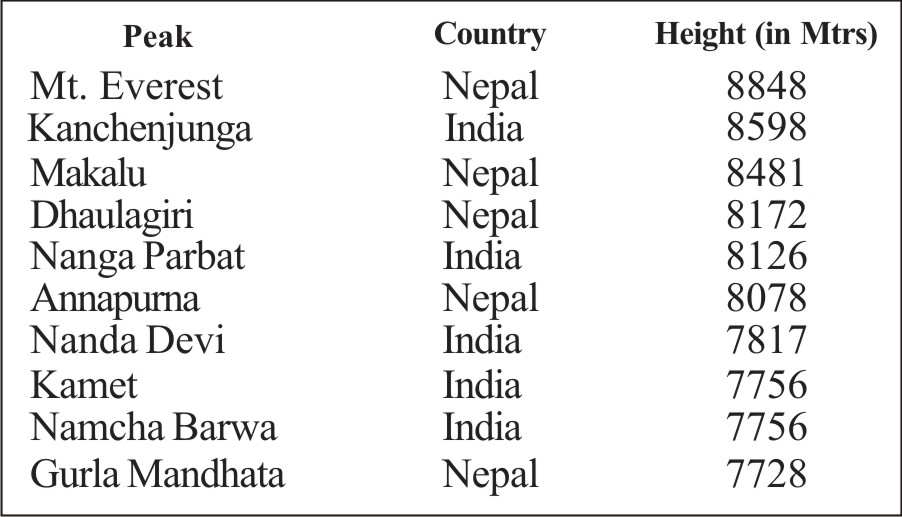
THE GREAT OR INNER HIMALAYAS OR HIMADRI:
- This is the northernmost range and is also known as 'Himadri'.
- This is the most continuous range.
- It contains the loftiest peaks.
- The average height of peaks in this range is 6,000 meters.
- All the prominent Himalayan peaks are in this range.
- The folds of the Great Himalayas are irregular in nature.
- The core of this part is composed of granite.
- Because of the lofty heights, the peaks of this range are perennially covered with snow.
- Famous glaciers like the Siachen Glacier, the Gangotri and Yamunotri, etc.
Some of the highest peaks of the Himalayas are: -
THE LESSER HIMALAYA OR HIMACHAL:
- This range lies towards the south of the Great Himalayas.
- The altitude of peaks in this range varies from 3,700 to 4,500 meter.
- Average width of this range is 50 km.
- This range is mainly composed of highly compressed and altered rocks.
- The most important mountain range here is the Pir Panjal mountain range and it is the longest range.
- Dhaula Dhar and Mahabharat mountain ranges are also important ranges of lesser himalayas.
- All great valleys like Kashmir Valley, Kangra Valley, Kullu Valley are present here.
- This region is also known as for its hill stations (for e.g. Kullu,-Manali, Kufri, Shimla, Mussoorie, Nanital, etc.).
THE SHIWALIKS:
- The outermost range of the Himalayas is known as Shiwaliks, also known as Manak Parbat in ancient times.
- The altitude varies between 900 and 1100 meters in this range.
- The width varies between 10 to 50 km.
- These ranges are composed of unconsolidated sediments brought down by the rivers.
- The longitudinal valleys lying between the Himachal and Shiwaliks are called 'Dun'.
- Unlike typical river valleys, duns have a structural origin and are covered with boulders and gravel originating from the erosion of the Himalayas and the Shiwalik uplands. Major duns found in the region are Dehra, Kothri, Chaukham, Patli and Kota. The dun of Dehra is the
 biggest with a length of 35 km and width of 25 km.
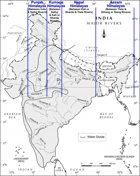
HIMALAYAN REGIONS FROM WEST TO EAST:
- Himalayas have also been divided on the basis of regions from west to east. The division has been done on the basis of the rivers flowing in the himalayan regions. Following is the division: -
- Punjab Himalayas: This part lies between the Indus and Sutlej. They are also known as Kashmir Himalaya and Himachal Himalaya.
- Kumaon Himalayas: This part lies between Sutlej and Kali rivers.
- Nepal Himalayas: This part lies between the Kali and Tista rivers.
- Assam Himalayas: This part lies between the Tista and Dihang rivers.
- Some regional names of himalayas are: - Sagarmatha Himal , Annapurna Himal , Ganesh Himal, Langtang Himal, Manaslu Himal , Rolwaling Himal, Jugal Himal, Gauri Sankar Himal, Kanjirowa Himal, Khumbu Himal, Dhaulagiri Himal, Purvachal, etc.
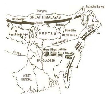
EASTERN HILLS AND MOUNTAINS:
- The Brahmaputra marks the eastern border of the Himalayas.
- Beyond the Dihang gorge, the Himalayas bend sharply towards south and form the Eastern hills or Purvachal.
- These hills run through the north eastern states of India.
- They are mostly composed of sandstones (i.e. Sedimentary rocks).
- These hills are covered with dense forest.
- These hills are composed of the Patkai Hills, Naga Hills, Manipuri Hills and Mizo Hills.
2.THE NORTHERN PLAIN OF INDIA:
- The northern plain of India is formed by three river systems, i.e. the Indus, the Ganga and the Brahmaputra; along with their tributaries.
- This plain is composed of alluvial soil which has been deposited over millions of years.
- The total area of the northern plain is about 7 lakh square kilometer.
- It is about 2400 km long.
- Width is about 240 to 320 km .
- Northern plains are most densely populated areas of the country.
- Here we find alluvial soil, thus making the plain very fertile and agriculturally very productive.
- Because of the three river systems, i.e. the Indus, the Ganga and the Brahmaputra; along with their tributaries, availability of water is there in abundance through the year.
- The rivers in their lower course split into numerous channels or streams due to the deposition of silt. These channels or streams are known as Distributaries.
- The northern plain is divided into three sections, i.e. the Punjab Plain, the Ganga Plain and the Brahmaputra Plain.
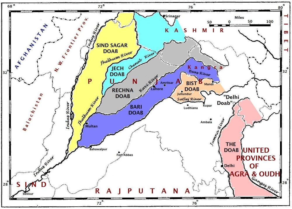
Punjab Plains:
- The Punjab plains form the western part of the northern plain.
- This is formed by the Indus and its tributaries; like Jhelum, Chenab, Ravi, Beas and Sutlej.
- A major portion of this plains is in Pakistan.
- Doabs are found in Punjab plains.
- Doab (do, "two" + ab, "water" or "river"). It as "a region or land lying between and reaching to the meeting of the two rivers.
Ganga Plains:
- This plain extends between Ghaggar and Tista rivers.
- The northern states, Haryana, Delhi, UP, Bihar, part of Jharkhand and West Bengal in the east lie in the Ganga plains.
Brahmaputra Plains:
- This plain forms the eastern part of the northern plain and lies in Assam.
Based on the relief features; the northern plain can be divided into four regions, viz. Bhabar, Terai, Bhangar and Khadar.
1. Bhabar:
- After descending from the mountains, the rivers deposit pebbles in a narrow belt.
- The width of this belt is about 8 to 16 kms.
- It lies parallel to the Shiwaliks.
- Bhabhar is the gently-sloping coarse alluvial zone below the Siwalik Hills (outermost foothills of Himalayas) where streams disappear into permeable sediments. The underground water level is deep in this region.
2. Terai:
- The terai region lies towards south of the bhabar belt.
- In this region, the streams reappear and make a wet, swampy and marshy region.
- This region was full of forest and wildlife but after partition all this area was cleared and was converted into agricultural land for the settlement of the migrants.
3. Bhangar:
- Bhangar is the largest part of the northern plain and is composed of the oldest alluvial soil.
- They lie above the flood plains. They resemble terraces.
- The soil of this region is locally known as kankar and is composed of calcareous deposits.
4. Khadar:
- The floodplains formed by younger alluvium are called Khadar.
- The soil in this region is renewed every year and is highly fertile.
- This region is very suitable for intensive agricultural activities.
3.THE PENINSULAR PLATEAU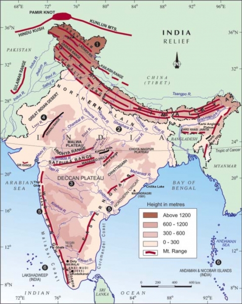
- The peninsular plateau is a tableland which contains igneous and metamorphic rocks.
- It is composed of the oldest rocks because it was formed from the drifted part of the Gondwana land.
- Broad and shallow valleys and rounded hills are the characteristic features of this plateau.
- The plateau can be broadly divided into two regions, i.e. the Central Highlands and the Deccan Plateau.
- One of the important features of the peninsular plateau is the black soil area which is known as the Deccan Trap.
- This black soil originated from the volcanic eruption. Thus, it has igneous rocks.
The Central Highlands:
- The Central Highlands lies to the north of the Narmada river.
- It covers the major portion of the Malwa plateau.
- Location:
- North of Narmada river.
- Vindhya ranges in the South.
- Aravalis in the North West.
- Covers Malwa plateau, Bundelkhand , Baghelkhand and Chhotanagpur plateau.
- The rivers in this region flow from southwest to northeast (i.e. Chambal, Sind, Betwa, Ken, Son, etc.); which indicates the slope of this region.
- It is wider in the west and narrower in the east.
- Bundelkhand and Baghelkhand mark the eastward extension of this plateau.
- The plateau further extends eastwards into the Chhotanagpur plateau.
The Deccan Plateau:
- The Deccan Plateau lies to the south of the Naramada river.
- It is triangular in shape.
- The slope of the Deccan Plateau is from west to east.
- Most of the rivers flow from west to east.
- Location:
- The Satpura range makes its northern part.
- The Mahadev, Kaimur Hills and Maikal range make its eastern part.
- It extends into the north east which encompasses Meghalaya, Karbi-Anglong Plateau and North Cachar Hills.
- Garo, Khasi and Jaintia hills are the prominent ranges; starting from west to east.
Western Ghats & Eastern Ghats:
- Western Ghats stretch from the Tapi River to Kanayakumari. But The Eastern Ghats stretch from Mahanadi Valley to the Nilgiris in the south.
- Western Ghat's average width is 50 to 80 km. But Eastern Ghat's width varying from 100 to 200 km.
- Western Ghats is source of many large rivers But no big river originates from the Eastern Ghats.
- Western Ghats are continuous and can be crossed through passes only. But Eastern Ghats has been divided into several parts by large rivers.
- Western Ghats average elevation is 900 to 1,600 meters But the average elevation of Eastern Ghats is about 600 metres above sea level.
- Highest Peak of Western Ghats: Anai Mudi (2695 meters).
- Highest Peak of Eastern Ghats: Mahendragiri (1501 meters).
- Western ghats receives orographic type of rainfallal. South-west monsoons coming from the Arabian Sea and causes heavy rainfall. Eastern Ghats is almost parallel to the monsoons coming from the Bay of Bengal and does not cause much rainfall.
4.THE INDIAN DESERT:
- The Indian desert is also known as the Thar Desert.
- The Indian desert lies towards the western margins of the Aravali Hills.
- This region gets very less rainfall which is less than 150 mm in a year.
- The climate is dry and vegetation is found is very less.
- Luni is the only large river but some streams appear during rainy season.
- Kindly note: The Luni is a river of western Rajasthan. It originates in the Pushkar valley of the Aravalli Range, near Ajmer and ends in the marshy lands of Ran of Kutch in Gujarat.
- Crescent-shaped dunes (barchans) are found in this area.
5.THE COASTAL PLAINS OF INDIA:
- The Western Coastal Plains is a thin strip of coastal plain with a width of 50 kms between the Arabian Sea and the Western Ghats.
- It is divided into three sections. The Konkan; (Mumbai – Goa) in the north. The Kannada Plain makes the central part and the Malabar coast stretches in the south.
- The Eastern Coastal Plains is a strip of coastal plain with a width of 100 - 130 kms between the Bay of Bengal and the Eastern Ghats
- It is divided into two parts. The northern part is called Northern Circar. The southern part is called the Coromandel Coast.
- Extensive deltas are formed by large rivers like Mahanadi, Godavari, Krishna and Kaveri.
- Chilika lake is an important feature along the eastern coast. It is the largest salt water lake in India.
6.THE ISLANDS OF INDIA:
India has two group of islands (i.e. Lakshadweep in the Arabian Sea and Andaman & 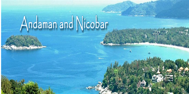 Nicobar Islands in the Bay of Bengal).
- The Lakshadweep Islands covers an area of 32 sq kms. It got its name in the year 1973.
- The administrative headquarters of Lakshadweep is at Kavaratti Island.
- This group of islands is composed of small coral islands.
- This group of islands is rich in terms of biodiversity (flora & fauna).
- The Andaman & Nicobar Islands are located in the Bay of Bengal.
- These islands are bigger in size and has more number of islands.
- This group of islands can be divided into two groups. The Andaman is in the north and the Nicobar is in the south.
- These islands are located close to equator and thus, experience equatorial type of climate and also have thick forest cover.
- These islands too have rich biodiversity (flora & fauna).
-----x-----X-----x-----
 2017-18_0_o.jpg)