Nirman Care - an educational blog

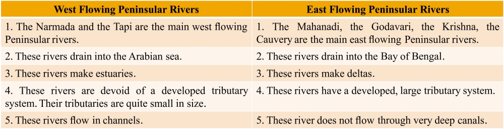
Class IX: Chapter 5 (Natural Vegetation & Wildlife) Questions & Answers

Q1. Define Virgin Vegetation.
Ans: The vegetation which has been left undisturbed by humans for a long time is called virgin vegetation. The virgin vegetation, which are purely Indian are known as endemic or indigenous species but those which have come from outside India are termed as exotic plants.

Q2. Define an ecosystem.
Ans: All the plants and animals in an area are interdependent on each other. The plants and animals, along with their physical environment make the ecosystem. Interrelation between plants and animals in the natural environment is called Ecosystem.

Q3. What factors are responsible for the distribution of plants and animals in India?
Ans: Factors responsible for the distribution of plants and animals in India are:
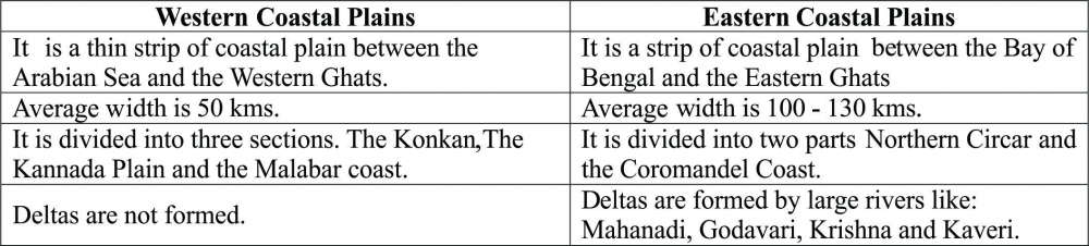
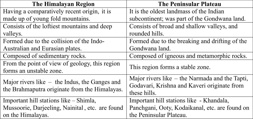
(a) Relief: Land and soil
(b) Climate: Temperature, Humidity, Photoperiod and Precipitation.

Q4. What is a bio-reserve? Name the four biosphere reserves in India which have been included in the world network of Biosphere reserves.
Ans: A biosphere reserve is an area of land or water that is protected by law in order to support the conservation of ecosystems, as well as the sustainability of mankind's impact on the environment.
Four biosphere reserves in India which have been included in the world network of Biosphere reserves are:
(a) Sunderbans in West Bengal
(b) Nanda Devi in Uttaranchal,
(c) The Gulf of Mannar in Tamil Nadu
(d) The Nilgiris (Kerala, Karnataka and Tamil Nadu).

Q5. Quite a few species of plants and animals are endangered in India. Why?
Ans: Species of some plants and animals are on the verge of extinction as their population has decreased considerably. Such species are known as "Endangered Species".
Following are the reasons behind species becoming endangered:
(a) Increase in population.
(b) Urbanization and Industrialization.
(c) Large scale deforestation.
(d) Pollution.
(e) Hunting for pleasure and commercial purpose, etc.

Q6. Name different types of Vegetation found in India and describe the vegetation of high altitudes.
Ans: There are five major types of vegetation in India: Tropical Rainforests, Tropical Deciduous Forests, Tropical Thorn Forests and Scrubs, Montane Forests and Mangrove Forests.

Montane Forest:
(a) The forests in the mountainous areas are called montane forest.
(b) Different types of vegetation are found at different altitudes in the mountains.
     (i) The wet temperate type of forest is found between a height of 1000 and 2000 meter. Evergreen broad-leaf             trees such as oak and chestnut abound in such forests.
     (ii) Between the heights of 1500 and 3000 meters, Coniferous trees; like Pine, Deodar, Silver Fir, Cedar, etc.              are found.
     (iii) At the height of 3600 meters, alpine vegetation is found; such as Silver Fir, Junipers, Pines, Birches, etc.               are found.
     (iv) At the higher altitude Tundra vegetations are found; such as Mosses and Lichens.
(c) Kashmir Stag, Wild Sheep, Yak, Snow Leopard, Bear, Rare Red Panda, etc. are the common animals in these forests.

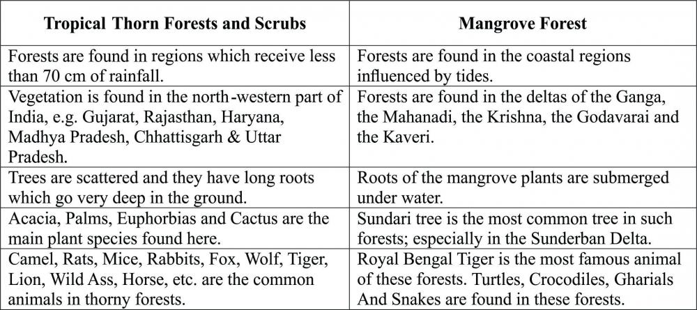
Q7. Distinguish between Tropical Thorn Forests and Scrubs Forest and Mangrove Forests.
Ans:


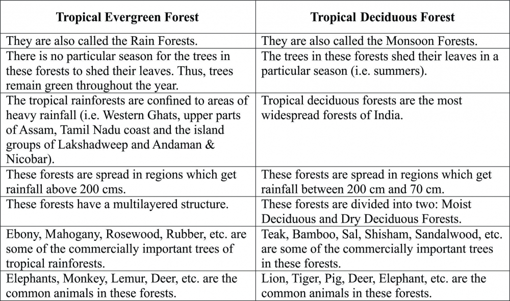
Q8. Distinguish between Tropical Evergreen Forest and Deciduous Forests.

Ans:


Q9. In India, what are the various steps taken to conserve forest and wildlife?
Ans: Following are few steps that have been taken to conserve forest and wildlife:
(a) National Forest Policy framed by the government should be implemented.
(b) National Parks, Wildlife Sanctuaries, Bioreserves, Botanical Gardens have been setup.
(c) Special Projects (E.g. Project Tiger, Project Elephant, etc.).
(d) Celebration of Van Mahotsav. Every National festival is followed by tree plantation ceremony.
(e) Controlling of deforestation and overgrazing. Large scale afforestation or planting of tress is undertaken.
(f) Social Awareness Programmes to be implemented.
(g) Wildlife Protection Act 1972.

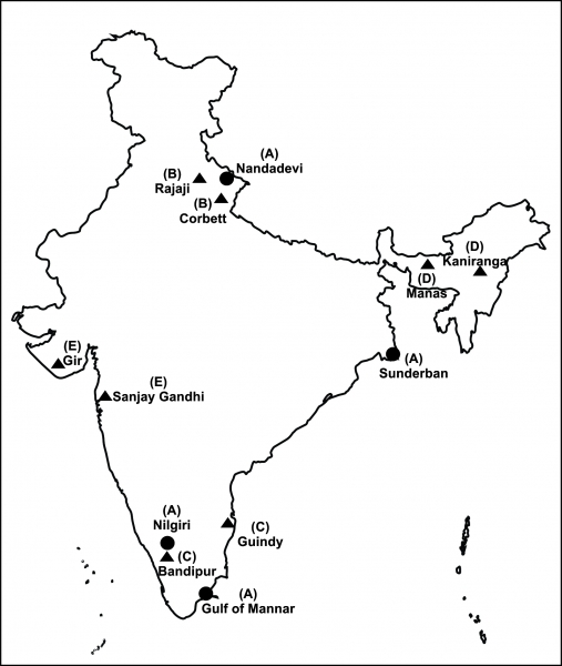
 Q10. On the outline map of India, label the following:
(A) Four Biosphere reserves in India, included in the world network of Biosphere reserves.
(B) Two National Parks each in Northern parts of the Country.
(C) Two National Parks each in Southern parts of the Country.
(D) Two National Parks each in Eastern parts of the Country.
(E) Two National Parks each in Western parts of the Country.
Ans:


-----x-----X-----x-----

Class IX: Chapter 4 (Climate) Question & Answers

Q1. Name the controls affecting the climate of any place.
Ans: There are six major controls of the climate of any place. They are:
(a) Latitude                                 (b) Altitude                                     (c) Pressure and Wind System
(d) Distance from the Sea           (e) Ocean Currents                         (f) Relief Features.

Q2. What are the elements of weather and climate?
Ans: There are the five major elements of weather and climate, i.e. Temperature, Atmospheric Pressure, Wind, Humidity and Precipitation

Q3. What are Jet Streams?
Ans: Fast flowing air currents in a narrow zone in the upper atmosphere are known jet streams.

Q4. Define monsoons. What do you understand by "break" in monsoon?
Ans: The seasonal reversal in wind direction during a year is called monsoon. The word "Monsoon" has been derived from an Arabic word called "Mausim" which means "Season".
Monsoon tends to have 'breaks' in rainfall; which means that there are wet and dry spells in between. The monsoon rains take place only for a few days at a time and then come the rainless intervals.

Q5. Why the monsoon is considered a unifying bond?
Ans: Following are few of the reasons why the monsoon is considered as a unifying bond in India:
(a) The Indian landscape, its flora and fauna, etc. are highly influenced by the monsoon.
(b) The entire agricultural calendar in India is governed by the monsoon.
(c) Most of the festivals in India are related to agricultural cycle. These festivals may be known by different names in different parts of the country, but their celebration is decided by the monsoon.
(d) It is also said that the river valleys which carry the rainwater also unite as a single river valley unit.

Q6. Discuss the mechanism of monsoons.
Ans: Following are the factors responsible for the mechanism of monsoon:
(a) The Sun causes differential heating and cooling of land and water. This creates low pressure on the landmass of India and high pressure over the ocean surface.
(b) The Inter Tropical Convergence Zone (ITCZ) is normally positioned about 5°N of the equator. It shifts over the Ganga plains during summer. It is also known as the monsoon trough during the monsoon season.
(c) The high pressure area, east of Madagascar is approximately 20°S over the Indian Ocean. This area affects the Indian Monsoon.
(d) The Tibetan plateau gets intensely heated during summer. This results in strong vertical air currents and formation of low pressure over the plateau. This low pressure zone is about 9 km above the sea level.
(e) The westerly jet stream move to the north of the Himalayas, and the tropical easterly jet stream moves over the Indian Peninsula during summer.
(f) The periodic change in pressure conditions between Pacific Ocean and the Indian Ocean that is known as the Southern Oscillation or SO also affects the monsoon.
(g) The difference in pressure over Tahiti (18°S/149°W) in the Pacific Ocean and Darwin (12°30'S/131°E) lies in northern Australia predicts the intensity of the monsoons. If the pressure differences are negative, it means a below average and late monsoon.

Q7. Give an account of weather conditions and characteristics of the cold season.
Ans: Following are the features of the cold season:
(a) The winter season begins from mid-November and till February; in northern India. December and January are the coldest months.
(b) The temperature goes low in the northern plains, while moderate in Chennai.
(c) As the northeast trade winds blow from land to sea, most parts of the country experience a dry season.
(d) The weather is usually marked by clear sky, low temperatures and low humidity and weak variable winds.
(e) The inflow of the cyclonic disturbances from the west and the northwest is a characteristic feature of the cold weather over the northern plains.
(f) These low-pressure over the Mediterranean Sea and Western Asia move into India that causes winter rains over the plains and snowfall in the mountains.
(g) The winter rainfall is in small amount but is very important for the rabi crop. This rainfall is locally known as mahawat.
(h) The peninsular region does not get a well-defined winter because of the moderating influence of the sea.

Q8. Write the characteristics of the retreating monsoon or the transition season.
Ans: Following are the characteristics of the retreating monsoon or the transition season:
(a) During October-November, the sun apparently moves towards the south. Thus, the monsoon trough over the northern plains becomes weaker and the south-west monsoon winds start withdrawing. The monsoon withdraws from the northern plains by the beginning of October.
(b) The retreat of the monsoon is marked by clear skies and rise in temperature. Day temperatures are high, nights are cool and pleasant.
(c) High temperature and humidity, makes the weather quite uncomfortable during the day. This is commonly known as "October Heat".
(d) The temperature begins to fall rapidly in northern India by the second half of October.
(e) The low-pressure conditions over northwestern India move to the Bay of Bengal by early November.
(f) This shift leads to cyclonic depressions over the Andaman Sea. These cyclones usually cross the eastern coasts of India and cause heavy and widespread rain. These cyclones may also arrive at the Coasts of Orissa, West Bengal and Bangladesh.
(g) These cyclones contribute to the bulk of the rainfall of the Coromandel Coast.

Q9. Describe the onset and withdrawal of the monsoons in India.
Ans: Onset:
(a) Generally, the monsoon arrives at the southern tip of the Indian peninsular by the first week of June. Subsequently, it divides into two branches, viz. the Arabian Sea branch and the Bay of Bengal branch.
(b) The Arabian Sea branch reaches Mumbai about ten days later, i.e. around 10th of June. The Bay of Bengal rapidly advances and reaches Assam in the first week of June.
(c) The monsoon winds are then deflected by high mountains and move towards west over the Ganga plains. The Arabian Sea branch of the monsoon arrives over Surashtra-Kuchchh and central part of the country by mid-June.
(d) The Arabian Sea and the Bay of Bengal branches of the monsoon merge over the northwestern part of the Ganga plains.
(e) Delhi usually receives monsoon showers from the Bay of Bengal branch by the end of June.
(f) Western Uttar Pradesh, Punjab, Haryana, and eastern Rajasthan experience monsoon by the first week of July. The monsoon reaches Himachal Pradesh and the rest of the country by mid-July.

Withdrawal: Withdrawal or the retreat of the monsoon is a more gradual process.
(a) The monsoon begins to withdraw from the northwestern states of India by early September.
(b) The monsoon withdraws completely from the northern part of the Indian peninsular by mid-October.
(c) The monsoon withdraws from the rest of the country by early December.
(d) The islands receive the very first monsoon showers from the first week of April to the first week of May; progressively from south to north. The withdrawal of monsoon in the islands takes place from the first week of December to the first week of January.

Q10. On an outline map of India, show the following:
(a) Areas receiving rainfall over 400 cms.
(b) Areas receiving less than 20 cms of rainfall.
(c) The direction of the south-west monsoon over India.
(d) The Wettest place of the World.
(e) City in the eastern coast having an average temperature between 24-25 degree Celsius in the winter season.
Ans:


-----x-----X-----x-----

Class IX: Chapter 3 (Drainage) Questions & Answers

Q1. Which two peninsular rivers flow towards the west?
Ans: The Narmada and the Tapi are the two major peninsular rivers which flow towards the west and drains into the Arabian Sea.

Q2. Explain the following: (a) Drainage Basin    (b) Water Divide    (c) River System
Ans: (a) Drainage Basin: The area drained by a single river system is known as Drainage Basin. E.g. Basin of the River Ganga and its tributaries.
(b) Water Divide: Any elevated area such as an upland that separates two drainage basins is called a water divide. E.g. Ambala is located on the water divide between The Indus and The Ganga.
(c) River System: Small streams flowing from different directions come together to form the main course of the river and ultimately, drains into the seas or the oceans. Thus, the river along with its tributaries is known as River System. E.g. The Indus River System.

Q3. Write a note on National River Conservation Plan (NRCP).
Ans: The activities of Ganga Action Plan (GAP) phase-I, initiated in 1985, were declared closed on 31st March 2000. The Steering Committee of the National River Conservation Authority reviewed the progress of the GAP and necessary correction on the basis of lessons learnt and experiences gained from GAP Phase-I. These have been applied to the major polluted rivers of the country under the NRCP.
The Ganga Action Plan (GAP) Phase-II, has been merged with the NRCP. The expanded NRCP now covers 152 towns located along 27 interstate rivers in 16 states. Under this action plan, pollution abatement works are being taken up in 57 towns. A total of 215 schemes of pollution abatement have been sanctioned. So far, 69 schemes have been completed under this action plan. A million litres of sewage is targeted to be intercepted, diverted and treated.

Q4. Define lake. Explain the different types of lakes.
Ans: A large water body which is surrounded by land is called a lake.
Following are the different types of lakes:
(a) Ox-bow Lake: A lake formed when a meandering river is cut off from the mainstream. The shape of this lake resembles an ox-bow.
(b) Lagoon: When the lake is formed by spits and bars in coastal areas, it is called a lagoon. Chilika lake, Pulicat lake, Kolleru lake, etc. are examples of lagoon.
(c) Glacial Lake: A lake formed by melting of glacier is called a glacial lake. Most of the lakes in the Himalayan region are glacial lakes. Wular lake (Jammu & Kashmir) is the largest freshwater lake in India. It was formed by tectonic activity.
(d) Man Made Lakes: Gobind Sagar is a man-made reservoir situated in Bilaspur District, Himachal Pradesh.

Q5. Explain the different types of drainage patterns.
Ans: Depending on the slope of land, underlying rock structure and climate of an area, the streams in a drainage basin form certain patters. Different types of drainage pattern are as follows:
(a) Dendritic Drainage Pattern: When the river channel follows the slope of the terrain, it develops dendritic pattern. The stream and its tributaries resemble the branches of a tree. Hence, it is called dendritic pattern.
(b) Trellis Drainage Pattern: When a river is joined by its tributaries at almost right angles, it develops a trellis pattern. Trellis pattern develops where hard and soft rocks exist parallel to each other.
(c) Rectangular Drainage Pattern: When rocks are strongly joined, then rectangular pattern develops.
(d) Radial Drainage Pattern: When the streams flow in different directions from a central peak or dome like structure, a radial pattern is developed.

Q6. Rivers and lakes hold a great importance in the country's economy; mention some economic benefits of rivers and lakes.
Ans:
Economic benefits of rivers:
1. Rivers have been a source of food since pre-history, almost all the civilizations developed along the river banks.
2. Rivers are also used for irrigation, hydro-power generation.
3. Rivers are used for navigation. They provide the cheapest inland means of transport.
4. Water from the river is the basic natural resource essential for various day-to-day activities of human beings.
5. It is also a rich source of fresh water fish.

Benefits of a Lakes:
1. A lake helps in preventing flood by regulating the flow of river.
2. During dry seasons, a lake helps to maintain an even flow of the river.
3. Lakes can also be used for generating hydel power.
4. Tourism development.
5. Maintain aquatic ecosystem.

Q7. Explain the major features of the following:
(a) The Ganga River System         (b) The Indus River System
(c) The Godavari River System    (d) The Narmada River System
Ans:
(a) The Ganga River System:
• The river Ganga in its origin state is known as Bhagirathi. It is fed by the Gangotri Glacier.
• The total length of river Ganga is 2500 km.
• Bhagirathi is joined by Alaknanda at Devprayag in Uttarakhand. Ganga emerges from the mountains on to the plains at Haridwar.
• Yamuna, Ghaghara, Gandak and Kosi, Chambal, Betwa and Son are the major tributaries of Ganga. River Yamuna meets Ganga at Allahabad.
• After taking waters from various tributaries, Ganga flows towards east till Farakka (West Bengal). The river bifurcates at Farakka. The Bhagirathi-Hooghly (a distributary) flows towards south to the Bay of Bengal.
• The mainstream flows southwards into Bangladesh; where it is joined by the Brahmaputra. It is known as Meghna.
• Finally, the Ganga and the Brahmaputra flow into the Bay of Bengal forming the Sunderban Delta.

(b) The Indus River System:
• The river Indus originates in Tibet; near Lake Mansarowar. It enters India in the Ladakh district of Jammu & Kashmir.
• Zaskar, Nubra, Shyok and Hunza are the main tributaries which join the Indus in Kashmir region.
• After flowing through Baltistan and Gilgit, the Indus emerges from the mountains at Attock.
• Sutlej, Beas, Ravi, Chenab and Jhelum join together and enter the Indus near Mithankot in Pakistan.
• After that, the Indus flows southwards and finally reaches the Arabian Sea, east of Karachi.
• Indus is 2900 km long.
• The Indus river basin covers parts of Jammu & Kashmir, Himachal Pradesh and Punjab. The rest of the portion is in Pakistan.

(c) The Godavari River System:
• It originates from the slopes of the Western Ghats in Nasik district of Maharashtra and drains into the Bay of Bengal.
• This is the longest Peninsular River. This river is popularly known as "Dakshin Ganga".
• The Godavari is about 1500 km long.
• The Godavari basin covers parts of Maharashtra, Madhya Pradesh, Orissa, Telangana and Andhra Pradesh.
• The Purna, the Wardha, the Pranhita, the Manjra, the Wainganga, the Penganga, etc. are the main tributaries of Godavari River.

(d) The Narmada River System:
• The Narmada raises in the Amarkantak hills (Maikal Range) in the Madhya Pradesh.
• The river flows towards the west through rift valleys. The Narmada basin covers parts of Madhya Pradesh and Gujarat.
• All the tributaries of the Narmada are very short. Most of the tributaries join the Narmada at right angles.
• The river travels a distance of 1,312 km.
• The major tributaries of the Narmada River are the Banjar River, the Barna River, the Tawa River.

Q8. Discuss the significant difference between the Himalayan and the Peninsular rivers.
Ans:

Q9. Compare the east flowing and the west flowing rivers of the peninsular plateau.
Ans:


Q10. Map Work.
(a) Ganga River           (b) Satluj River           (c) Damodar River           (d) Krishna River
(e) Narmada River      (f) Tapi River               (g) Mahanadi River         (h) Brahmaputra River
(i) Indus River             (j) Yamuna River        (k) Chilika Lake               (l) Sambhar Lake
(m) Wular Lake          (n) Pulicat Lake           (o) Kolleru Lake              (P) Vembanad Lake

Ans: Please refer the map given below and label properly on the map.


-----x-----X-----x-----

Class IX: Chapter 3 - Drainage

 Objectives and Goals:
1. Drainage.
2. Drainage Basin, Water Divide and Perennial.
3. The Drainage System of India.
4. The division of Indian rivers (i.e. The Himalayan Rivers and the Peninsular Rivers).
5. The Drainage Pattern (i.e. Dendritic, Trellis, Rectangular and Radial Patterns).
6. The Course of the River and features formed by river during it's course.
7. The Himalayan Rivers (i.e. The Indus River System, The Ganga River System and The Brahmaputra River System).
8. The Peninsular Rivers (i.e. The Narmada Basin, The Tapi Basin, The Godavari Basin, The Mahanadi Basin, The Krishna Basin and The Kaveri Basin).
9. The Lakes and its value to the mankind.
10. The Role of rivers in the economy.
11. The River Pollution and how we can protect our rivers.
12. The National River Conservation Plan (NRCP).

 Drainage Patterns:
Depending on the slope of land, underlying rock structure and climate of an area, the streams in a drainage basin form certain patters. Different types of drainage pattern are as follows:
1. Dendritic Drainage Pattern: When the river channel follows the slope of the terrain, it develops dendritic pattern. The stream and its tributaries resemble the branches of a tree. Hence, it is called dendritic pattern.
2. Trellis Drainage Pattern: When a river is joined by its tributaries at almost right angles, it develops a trellis pattern. Trellis pattern develops where hard and soft rocks exist parallel to each other.
3. Rectangular Drainage Pattern: When rocks are strongly joined, then rectangular pattern develops.
4. Radial Drainage Pattern: When the streams flow in different directions from a central peak or dome like structure, a radial pattern is developed.
It is important to note that a combination of different patterns may develop in the same drainage basin.


Course of a River:
1. Rivers are the most important agents of degradation.
2. Work of the river depends on two factors: -
(a) The volume of Water.
(b) Slope of river beds.
3. Common features formed by river while flowing through mountains: -
(a) 'I' & 'V' shaped valleys.
(b) Gorges or Canyons (deep valleys).
(c) Waterfalls, etc.
4. Common features formed by river while flowing through plains: -
(a) Meanders(curves & large bends or loops)
(b) Oxbow Lakes
(c) Flood Plains
(d) Levees (slightly raised river banks)
5. Common features formed by river when it reaches near the sea: -
(a) River breakup into various streams called 'distributaries'.
(b) Delta


The Drainage System of India
The drainage systems in India can be divided into two major groups:
1. The Himalayan Rivers 2. The Peninsular Rivers.


1. The Himalayan Rivers:
The Himalayan Rivers: Most of the Himalayan Rivers are perennial (i.e. they have water throughout the year).
River System: A river along with its tributaries forms a river system.
The three major Himalayan River Systems are:
1. The Indus River System
2. The Ganga River System
3. The Brahmaputra River System


The Indus River System:

  • The river Indus originates in Tibet; near Lake Mansarowar. It enters India in the Ladakh district of Jammu & Kashmir.
  • Zaskar, Nubra, Shyok and Hunza are the main tributaries which join the Indus in Kashmir region.
  • After flowing through Baltistan and Gilgit, the Indus emerges from the mountains at Attock.
  • Sutlej, Beas, Ravi, Chenab and Jhelum join together and enter the Indus near Mithankot in Pakistan.
  • After that, the Indus flows southwards and finally reaches the Arabian Sea, east of Karachi.
  • Indus is 2900 km long.
  • The Indus plain has a very gentle slope.
  • A little over one-third of the Indus basin is located in India; in the states of Jammu & Kashmir, Himachal Pradesh and Punjab. The rest of the portion is in Pakistan.


 The Ganga River System:

  • The river Ganga in its origin state is known as Bhagirathi. It is fed by the Gnagotri Glacier.
  • Bhagirathi is joined by Alaknanda at Devprayag in Uttarakhand.
  • Ganga emerges from the mountains on to the plains at Haridwar.
  • Yamuna, Ghaghara, Gandak and Kosi are the major tributaries of Ganga.
  • Yamuna originates from the Yamunotri Glacier in the Himalayas. It meets Ganga at Allahabad.
  • Ghaghara, Gandak and Kosi rise in the Nepal Himalaya.
  • Chambal, Betwa and Son are the major tributaries which come from the peninsular uplands.
  • After taking waters from various tributaries, Ganga flows towards east till Farakka (West Bengal).
  • The river bifurcates at Farakka. The Bhagirathi-Hooghly (a distributary) flows towards south to the Bay of Bengal.
  • The mainstream flows southwards into Bangladesh; where it is joined by the Brahmaputra. It is known as Meghna.
  • Finally, the Ganga and the Brahmaputra flow into the Bay of Bengal forming the Sunderban Delta.
  • The total length of river Ganga is 2500 km.
  • Ambala is located on the water divide between Indus and Ganga.
  • Length of plains from Ambala to Sundarban detla is around 1800 kms. But the slope is only 300 metres.
  • In this area river develops large meanders.

 The Brahmaputra River System:

  • The Brahmaputra rises in Tibet; east of Mansarowar lake.
  • River Brahmaputra is a little longer than the river Indus.
  • Most of the course of the Brahmaputra lies outside India, popularly known as Tsangpo . It flows eastwards parallel to the Himalayas.
  • After reaching Namcha Barwa, it takes a "U" turn (also known as Hair Pin turn) and enters India in Arunachal Pradesh through a gorge known as Dihang. In this region the river is known as Dihang.
  • It is joined by Dibang, Lohit, Kenula and many other tributaries and finally forms the Brahmaputra in Assam.
  • Majuli (in Assam) is the largest riverine island in the world. The island had a total area of 1,250 square kms.
  • Unlike other north Indian rivers the Brahmaputra gets huge deposits of silt on its bed. This results in rising of the river bed.
  • River Brahmaputra is known by different names in different regions: (Tsangpo in Tibet, Brahmaputra in India & Jamuna in Bangladesh).


THE PENINSULAR RIVER SYSTEM

  • Most of the Peninsular Rivers are seasonal because they depend on rainfall for water.
  • These rivers have shorter and shallower courses; compared to the Himalayan rivers.
  • Most of the major rivers of the Peninsula flow eastwards and drain into the Bay of Bengal Major rivers are The Mahanadi, The Godavari, The Krishna and The Kaveri.
  • These rivers make deltas at their mouths.
  • The Narmada and Tapi are the only long rivers, which flow westwards and make estuaries.
  • The drainage basins of the peninsular rivers are smaller in size.

The main differences between Delta and Estuary are as follows:


The Narmada Basin:

  • The Narmada rises in the Amarkantak hills (Maikal Range) in the Madhya Pradesh.
  • The river flows towards the west through rift valleys.
  • The Narmada basin covers parts of Madhya Pradesh and Gujarat.
  • All the tributaries of the Narmada are very short.
  • Most of the tributaries join the Narmada at right angles.
  • The river travels a distance of 1,312 km.
  • The major tributaries of the Narmada river are the Hallon River, Banjar River, Barna River and Tawa River.

 The Tapi Basin:

  • The Tapi rises in the Satpura ranges, in Betul district of Madhya Pradesh.
  • The basin of Tapi covers parts of Madhya Pradesh, Gujarat and Maharashtra.
  • The river flows towards the west through rift valleys parallel to river Narmada.
  • The river travels a distance of 724 km.
  • Tributaries of the Tapti River are the Mindhola River, Girna River, Panzara River, Waghur River, Bori River and Aner River.

 The Mahanadi Basin:

  • This river originates in the highlands of Chhattisgarh and drains into the Bay of Bengal.
  • It is about 860 km long.
  • The Mahanadi basin covers Maharashtra, Chhattisgarh, Jharkhand and Orissa.

 The Godavari Basin:

  • This is the longest Peninsular river.
  • This river is popularly known as "Dakshin Ganga".
  • Its drainage basin is also the largest among the peninsular river basins.
  • The Godavari is about 1500 km long.
  • It originates from the slopes of the Western Ghats in Nasik district of Maharashtra and drains into the Bay of Bengal.
  • The Godavari basin covers parts of Maharashtra, Madhya Pradesh, Orissa and Andhra Pradesh.
  • Purna, Wardha, Pranhita, Manjra, Waiganga and Penganga are the main tributaries of Godavari.

 The Krishna Basin:

  • The Krishna originates near Mahabaleshwar and drains into the Bay of Bengal.
  • It is about 1400 km long.
  • Tungbhadra, Koyana, Ghatprabha, Musi and Bhima are some of its tributaries.
  • The Krishna basin covers Maharashtra, Karnataka and Andhra Pradesh.

The Kaveri Basin:

  • The Kaveri originates in the Brahmagiri range of the Western Ghats and drains into the Bay of Bengal.
  • It is about 760 km long.
  • Amravati, Bhavani, Hemavati and Kabini are its main tributaries.
  • The Kaveri basin covers Karnataka, Kerala and Tamil Nadu. .

 Lakes:

  • A large water body which is surrounded by land is called a lake.
  • Most of the lakes are permanent, while some contain water only during the rainy season.
  • Lakes are formed by the action of glaciers and ice sheets, by wind, river action and by human activities.

Types of Lakes:
1. Ox-bow Lake: A lake formed when a meandering river is cut off from the mainstream. The shape of this lake resembles an ox-bow.
2. Lagoon: When the lake is formed by spits and bars in coastal areas, it is called a lagoon. Chilika lake, Pulicat lake, Kolleru lake, etc. are examples of lagoon.
3. Glacial Lake: A lake formed by melting of glacier is called a glacial lake. Most of the lakes in the Himalayan region are glacial lakes. Wular lake (Jammu & Kashmir) is the largest freshwater lake in India. It was formed by tectonic activity.
4. Man Made Lakes: These lakes are created by human activities. Gobind Sagar is a man-made reservoir situated in Bilaspur District, Himachal Pradesh.

Benefits of a Lake:
1. A lake helps in preventing flood by regulating the flow of river.
2. During dry seasons, a lake helps to maintain an even flow of the river.
3. Lakes can also be used for generating hydel power.
4. Tourism development.
5. Maintain aquatic ecosystem.

 Role of rivers in the economy:

  • Rivers have been the centre of human civilization since ancient times.
  • Even today, many big cities are situated on the bank of a river.
  • River water is used for irrigation, navigation, hydroelectricity, fisheries, etc.

 River Pollution:

  • The growing domestic, municipal, industrial and agricultural demand for water from rivers naturally affects the quality of water.
  • As a result, more and more water is being drained out of the rivers reducing their volume.
  • On the other hand, a heavy load of untreated sewage and industrial effluents are emptied into the rivers.
  • This affects not only the quality of water but also the self-cleansing capacity of the river.

 National River Conservation Plan (NRCP)

  • The National River Conservation Directorate (NRCD) in the Ministry of Environment, Forests and Climate Change is implementing the Centrally Sponsored Schemes of National River Conservation Plan (NRCP) for conservation of rivers, lakes and wetlands in the country.
  • The objective of the River Action Plans is to improve water quality of rivers through implementation of pollution abatement schemes in identified polluted stretches of rivers.
  • NPCA aims at conserving aquatic ecosystems (lakes and wetlands) through implementation of sustainable conservation plans, and governed with application of uniform policy and guidelines.

 Ganga Action Plan (GAP)

  • Ganga Action Plan (GAP) Phase-I was launched in the year 1985 to improve the water quality of river Ganga and was completed in March 2000.
  • Phase-II of the programme was approved in stages from 1993 onwards which included tributaries of the river Ganga namely, Yamuna, Gomti, Damodar and Mahananda.
  • Pollution abatement works undertaken include, interception and diversion of raw sewage, setting up of sewage treatment plants, creation of low cost sanitation facilities, setting up of electric/improved wood crematoria and river front development.
  • GAP Phase–II is currently under implementation.
  • An expenditure of Rs. 896.05 crore has been incurred so far on Ganga under GAP and sewage treatment capacity of 1064 mld (million litres per day) has been created.


-----x-----X-----x-----

Class IX: Chapter 2 (Physical Features of India) Extra Questions for Practice

Q1. Name the six major physical features of India.
Q2. Theory of plate tectonics talks about seven major tectonic plates, name them.
Q3. Movement of plates results in which three different types of activities?
Q4. What is Faulting?
Q5. Name the different types of plate movements.
Q6. Explain the meaning of the word "Himalaya".
Q7. Write any five features of Himalayas.
Q8. Horizontally, the Himalayas are classified into how many types, name them.
Q9. Write any five features of the Inner Himalayas.
Q10. Name top five peaks of the Himalayas present in India.
Q11. Write any five features of the Lesser Himalayas.
Q12. Write any five features of the Shiwaliks.
Q13. What are "Duns"?
Q14. Name the division of Himalayas from West to East.
Q15. Name some of the eastern hills.
Q16. Name the major river systems forming the northern plain.
Q17. Write any five features of the northern plain.
Q18. What is "Doab"?
Q19. Name the divisions of northern plains based on the relief features.
Q20. Name the divisions of northern plains based on the flow of rivers.
Q21. Write any five features of the peninsular plateau.
Q22. Name the divisions of the peninsular plateau.
Q23. Which is the highest peak in the Eastern and Western Ghats?
Q24. Which are the major rivers flowing in the Central Highlands and in which direction?
Q25. Mention the location of the Central Highlands.
Q26. Mention the location of the Deccan Plateau.
Q27. Write any five features of the Indian Desert.
Q28. Write the divisions of western coastal plains.
Q29. Write the divisions of the eastern coastal plains.
Q30. Name the largest salt water lake in India located in the eastern coastal plains.
Q31. Name the group of islands located in the Arabian Sea and in the Bay of Bengal.


-----x-----X-----x-----

Class IX: Chapter 2 (Physical Features of India) Question and Answers

Q1. Explain the divisions of the Himalayas on the basis of regions from west to east.
Ans: On the basis of regions from west to east and the rivers flowing, the great Himalayas have been divided into four divisions:
(a) Punjab Himalayas: This part lies between the Indus and Sutlej. They are also known as Kashmir Himalaya and Himachal Himalaya.
(b) Kumaon Himalayas: This part lies between Sutlej and Kali rivers.
(c) Nepal Himalayas: This part lies between the Kali and Tista rivers.
(d) Assam Himalayas: This part lies between the Tista and Dihang rivers.

Q2. Write short notes on the following:
(a) The Indian Desert (b) The Central Highlands (c) The Island groups of India
Ans:
(a) The Indian Desert: The Indian desert lies towards the western margins of the Aravali Hills. This region gets scanty rainfall which is less than 150 mm in a year. Hence they climate is arid and vegetation is scanty. Luni is the only large river but some streams appear during rainy season. Crescent-shaped dunes (barchans) abound in this area.

(b) The Central Highlands: The Central Highlands lies to the north of the Narmada River. Central Highlands is broadly divided into two: The Malwa Plateau and the Chhotanagpur plateau. It covers the major portion of the Malwa plateau. The rivers in this region flow from southwest to northeast; which indicates the slope of this region. It is wider in the west and narrower in the east. Bundelkhand and Baghelkhand mark the eastward extension of this plateau.
The plateau further extends eastwards into the Chhotanagpur plateau; this area is very rich in minerals.

(c) The Island groups of India: The Lakshadweep Islands are in the Arabian Sea. Its area is 32 sq km. The administrative headquarters of Lakshadweep is at Kavaratti Island. This group of islands is rich in terms of biodiversity.
The Andaman and Nicobar Islands are bigger in size and has more number of islands. Its area is 8249 sq km. This group of islands can be divided into two groups. The Andaman is in the north and the Nicobar is in the south. These islands too have rich biodiversity.

Q3. What are tectonic plates? Name three types of stress build with the plates.
Ans: The crust of the earth is not in the form of a continuous plate rather in the form of broken pieces. These pieces of the earth's crust are called tectonic plates. Broadly, there are seven major plates: African Plate, Antarctic Plate, Eurasian Plate, Indo-Australian Plate, North American Plate, Pacific Plate and South American Plate.
Stress build with the plates leads to Folding, Faulting and Volcanic Activities.

Q4. Which part of India is called Purvachal? Mention few characteristics of Purvachal.
Ans: The Brahmaputra River marks the eastern boundary of the Himalayas. Beyond the Dihang gorge, the Himalayas bend sharply towards south and form the Eastern hills or The Purvachal.
Following are the characteristics of Purvachal:
(a) These hills run through the north eastern states of India.
(b) They are mostly composed of sandstones (i.e. Sedimentary rocks).
(c) These hills are covered with dense forest.
(d) These hills are composed of the Patkai Hills, Naga Hills, Manipuri Hills and Mizo Hills.

Q5. Explain the three major divisions of the Himalayas from north to south.
Ans: Three major divisions of the Himalayas from north to south are:
(a) The Great or Inner Himalaya or Himadri:
• This is the northernmost range and is also known as 'Himadri'.
• This is the most continuous range.
• The average height of peaks in this range is 6,000 meters.
• All the prominent Himalayan peaks are in this range.
• The folds of the Great Himalayas are irregular in nature.
• Because of the lofty heights, the peaks of this range are perennially covered with snow.
• Famous glaciers like the Siachen Glacier, the Gangotri and Yamunotri, etc.

(b) The Lesser Himalaya or Himachal:
• This range lies towards the south of the Great Himalayas.
• The altitude of peaks in this range varies from 3,700 to 4,500 meter.
• Average width of this range is 50 km.
• The most important mountain range here is the Pir Panjal mountain range and it is the longest range. Dhaula Dhar and Mahabharat are also important ranges of lesser Himalayas.
• All great valleys like Kashmir Valley, Kangra Valley, Kullu Valley are present here.
• This region is also known as for its hill stations (for e.g. Kullu,-Manali, Kufri, Shimla, Mussoorie, Nanital, etc.).

(c) The Outer Himalayas or the Shiwaliks:
• The altitude varies between 900 and 1100 meters in this range.
• The width varies between 10 to 50 km.
• These ranges are composed of unconsolidated sediments brought down by the rivers.
• The longitudinal valleys lying between the Himachal and Shiwaliks are called 'Dun'. E.g. The dun of Dehra, it is the biggest with a length of 35 km and width of 25 km.

Q6. Distinguish between Western Coastal Plains and Eastern Coastal Plains.
Ans:

Q7. Distinguish between Western Ghats and Eastern Ghats.
Ans:

Q8. Explain the Northern Plains of India with its divisions on the basis of the relief features.
Ans: Based on the relief features; the northern plain can be divided into four regions, viz. Bhabar, Terai, Bhangar and Khadar.

(a) Bhabar: After descending from the mountains, the rivers deposit pebbles in a narrow belt. The width of this belt is about 8 to 16 kms. It lies parallel to the Shiwaliks. Bhabhar is the gently-sloping coarse alluvial zone below the Siwalik Hills (outermost foothills of Himalayas) where streams disappear into permeable sediments. The underground water level is deep in this region.

(b) Terai: The terai region lies towards south of the bhabar belt. In this region, the streams reappear and make a wet, swampy and marshy region. This region was full of forest and wildlife but after partition all this area was cleared and was converted into agricultural land for the settlement of the migrants.

(c) Bhangar: Bhangar is the largest part of the northern plain and is composed of the oldest alluvial soil. They lie above the flood plains. They resemble terraces. The soil of this region is locally known as kankar and is composed of calcareous deposits.

(d) Khadar: The floodplains formed by younger alluvium are called Khadar. The soil in this region is renewed every year and is highly fertile. This region is very suitable for intensive agricultural activities.

Q9. Contrast the relief of the Himalayan region with that of the Peninsular Plateau.
Ans: The following compares and contrasts between the reliefs of the Himalayan region with that of the peninsular plateau:

Q10. Map Work (Locate and Label):
Mountain Ranges:
(A) Karakoram Range
(B) Zasker Range
(C) Shiwalik Range
(D) Aravali Range
(E) Vindhya Range
(F) Satpura Range
(G) Western Ghats
(H) Eastern Ghats

Mountain Peaks:
(I) K2
(J) Kanchan Junga
(K) Anai Mudi,

Plateau:
(L) Deccan Plateau
(M) Chotta Nagpur Plateau
(N) Malwa plateau

Coastal Plains:
(O) Konkan Coast
(P) Malabar Coast
(Q) Coromandal Coast
(R) Northern Circar Coast

Ans:


-----x-----X-----x-----

Newer posts → Home ← Older posts