
Class IX: Chapter 3 (Drainage) Questions & Answers
Q1. Which two peninsular rivers flow towards the west?
Ans: The Narmada and the Tapi are the two major peninsular rivers which flow towards the west and drains into the Arabian Sea.
Q2. Explain the following: (a) Drainage Basin (b) Water Divide (c) River System
Ans: (a) Drainage Basin: The area drained by a single river system is known as Drainage Basin. E.g. Basin of the River Ganga and its tributaries.
(b) Water Divide: Any elevated area such as an upland that separates two drainage basins is called a water divide. E.g. Ambala is located on the water divide between The Indus and The Ganga.
(c) River System: Small streams flowing from different directions come together to form the main course of the river and ultimately, drains into the seas or the oceans. Thus, the river along with its tributaries is known as River System. E.g. The Indus River System.
Q3. Write a note on National River Conservation Plan (NRCP).
Ans: The activities of Ganga Action Plan (GAP) phase-I, initiated in 1985, were declared closed on 31st March 2000. The Steering Committee of the National River Conservation Authority reviewed the progress of the GAP and necessary correction on the basis of lessons learnt and experiences gained from GAP Phase-I. These have been applied to the major polluted rivers of the country under the NRCP.
The Ganga Action Plan (GAP) Phase-II, has been merged with the NRCP. The expanded NRCP now covers 152 towns located along 27 interstate rivers in 16 states. Under this action plan, pollution abatement works are being taken up in 57 towns. A total of 215 schemes of pollution abatement have been sanctioned. So far, 69 schemes have been completed under this action plan. A million litres of sewage is targeted to be intercepted, diverted and treated.
Q4. Define lake. Explain the different types of lakes.
Ans: A large water body which is surrounded by land is called a lake.
Following are the different types of lakes:
(a) Ox-bow Lake: A lake formed when a meandering river is cut off from the mainstream. The shape of this lake resembles an ox-bow.
(b) Lagoon: When the lake is formed by spits and bars in coastal areas, it is called a lagoon. Chilika lake, Pulicat lake, Kolleru lake, etc. are examples of lagoon.
(c) Glacial Lake: A lake formed by melting of glacier is called a glacial lake. Most of the lakes in the Himalayan region are glacial lakes. Wular lake (Jammu & Kashmir) is the largest freshwater lake in India. It was formed by tectonic activity.
(d) Man Made Lakes: Gobind Sagar is a man-made reservoir situated in Bilaspur District, Himachal Pradesh.
Q5. Explain the different types of drainage patterns.
Ans: Depending on the slope of land, underlying rock structure and climate of an area, the streams in a drainage basin form certain patters. Different types of drainage pattern are as follows:
(a) Dendritic Drainage Pattern: When the river channel follows the slope of the terrain, it develops dendritic pattern. The stream and its tributaries resemble the branches of a tree. Hence, it is called dendritic pattern.
(b) Trellis Drainage Pattern: When a river is joined by its tributaries at almost right angles, it develops a trellis pattern. Trellis pattern develops where hard and soft rocks exist parallel to each other.
(c) Rectangular Drainage Pattern: When rocks are strongly joined, then rectangular pattern develops.
(d) Radial Drainage Pattern: When the streams flow in different directions from a central peak or dome like structure, a radial pattern is developed.
Q6. Rivers and lakes hold a great importance in the country's economy; mention some economic benefits of rivers and lakes.
Ans:
Economic benefits of rivers:
1. Rivers have been a source of food since pre-history, almost all the civilizations developed along the river banks.
2. Rivers are also used for irrigation, hydro-power generation.
3. Rivers are used for navigation. They provide the cheapest inland means of transport.
4. Water from the river is the basic natural resource essential for various day-to-day activities of human beings.
5. It is also a rich source of fresh water fish.
Benefits of a Lakes:
1. A lake helps in preventing flood by regulating the flow of river.
2. During dry seasons, a lake helps to maintain an even flow of the river.
3. Lakes can also be used for generating hydel power.
4. Tourism development.
5. Maintain aquatic ecosystem.
Q7. Explain the major features of the following:
(a) The Ganga River System (b) The Indus River System
(c) The Godavari River System (d) The Narmada River System
Ans:
(a) The Ganga River System:
• The river Ganga in its origin state is known as Bhagirathi. It is fed by the Gangotri Glacier.
• The total length of river Ganga is 2500 km.
• Bhagirathi is joined by Alaknanda at Devprayag in Uttarakhand. Ganga emerges from the mountains on to the plains at Haridwar.
• Yamuna, Ghaghara, Gandak and Kosi, Chambal, Betwa and Son are the major tributaries of Ganga. River Yamuna meets Ganga at Allahabad.
• After taking waters from various tributaries, Ganga flows towards east till Farakka (West Bengal). The river bifurcates at Farakka. The Bhagirathi-Hooghly (a distributary) flows towards south to the Bay of Bengal.
• The mainstream flows southwards into Bangladesh; where it is joined by the Brahmaputra. It is known as Meghna.
• Finally, the Ganga and the Brahmaputra flow into the Bay of Bengal forming the Sunderban Delta.
(b) The Indus River System:
• The river Indus originates in Tibet; near Lake Mansarowar. It enters India in the Ladakh district of Jammu & Kashmir.
• Zaskar, Nubra, Shyok and Hunza are the main tributaries which join the Indus in Kashmir region.
• After flowing through Baltistan and Gilgit, the Indus emerges from the mountains at Attock.
• Sutlej, Beas, Ravi, Chenab and Jhelum join together and enter the Indus near Mithankot in Pakistan.
• After that, the Indus flows southwards and finally reaches the Arabian Sea, east of Karachi.
• Indus is 2900 km long.
• The Indus river basin covers parts of Jammu & Kashmir, Himachal Pradesh and Punjab. The rest of the portion is in Pakistan.
(c) The Godavari River System:
• It originates from the slopes of the Western Ghats in Nasik district of Maharashtra and drains into the Bay of Bengal.
• This is the longest Peninsular River. This river is popularly known as "Dakshin Ganga".
• The Godavari is about 1500 km long.
• The Godavari basin covers parts of Maharashtra, Madhya Pradesh, Orissa, Telangana and Andhra Pradesh.
• The Purna, the Wardha, the Pranhita, the Manjra, the Wainganga, the Penganga, etc. are the main tributaries of Godavari River.
(d) The Narmada River System:
• The Narmada raises in the Amarkantak hills (Maikal Range) in the Madhya Pradesh.
• The river flows towards the west through rift valleys. The Narmada basin covers parts of Madhya Pradesh and Gujarat.
• All the tributaries of the Narmada are very short. Most of the tributaries join the Narmada at right angles.
• The river travels a distance of 1,312 km.
• The major tributaries of the Narmada River are the Banjar River, the Barna River, the Tawa River.
Q8. Discuss the significant difference between the Himalayan and the Peninsular rivers.
Ans:
_0_o.jpg)
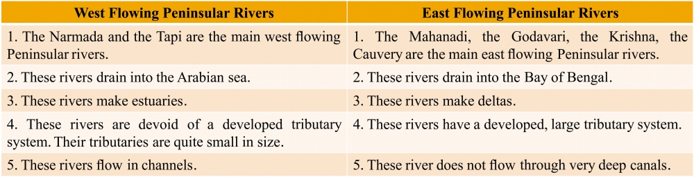
Q9. Compare the east flowing and the west flowing rivers of the peninsular plateau.
Ans:
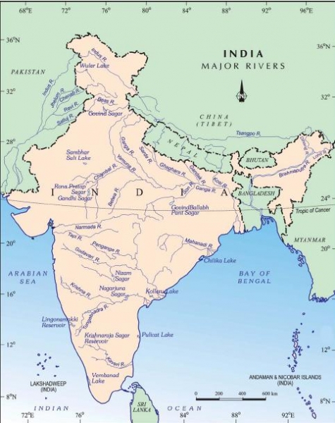
Q10. Map Work.
(a) Ganga River (b) Satluj River (c) Damodar River (d) Krishna River
(e) Narmada River (f) Tapi River (g) Mahanadi River (h) Brahmaputra River
(i) Indus River (j) Yamuna River (k) Chilika Lake (l) Sambhar Lake
(m) Wular Lake (n) Pulicat Lake (o) Kolleru Lake (P) Vembanad Lake
Ans: Please refer the map given below and label properly on the map.
-----x-----X-----x-----
There are no published comments.
New comment