
Class IX: Chapter 1 (India - Size and Location) Question & Answers
Q1. What is the location of India?
Ans: The mainland stretches from Latitude 8o4' North to 37o6' North and from Longitude 68o7' East to 97o25' East. The southernmost point in the Indian Territory, (in Great Nicobar Islands) is the Indira Point (6o45' North), while Kanya-Kumari, is the southernmost point of Indian mainland.
Q2. What is the size of India?
Ans: India is the seventh largest country in the world covering an area of 3.28 million square kilometers. India covers 2.4 % of the total geographical area of the world.
Q3. Name the states through which the Tropic of Cancer passes.
Ans: Tropic of Cancer passes through: Gujarat, Rajasthan, Madhya Pradesh, Chhattisgarh, Jharkhand, West Bengal, Tripura and Mizoram.
Q4. Name the countries which are larger than India.
Ans: Russia, Canada, USA, China, Brazil and Australia are the countries larger than India.
Q5. Which countries together make the Indian subcontinent?
Ans: India, Bangladesh, Pakistan, Sri Lanka, Maldives, Nepal and Bhutan are the countries that together make the Indian subcontinent.
Q6. Name all the neighboring countries of India.
Ans: In the northwest, India shares its boundaries with Pakistan and Afghanistan. In the north, India shares its boundaries with China, Nepal and Bhutan. In the east, India shares its boundaries with Bangladesh and Myanmar. In the south, Maldives and Sri Lanka are our neighboring countries. Sri Lanka is separated from India by a narrow channel of sea formed by Palk Strait.
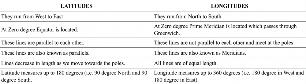
Q7. Distinguish between Latitudes and Longitudes.
Ans:
Q8. The central location of India at the head of the Indian Ocean is considered of great significance. Why?
Ans: The central location of India at the head of the Indian Ocean is considered of great significance because of the following reasons:
(a) India is centrally located on the world map.
(b) India has longest coastline on the Indian Ocean.
(c) It is surrounded by three water bodies, in the south by the Indian Ocean, in the east by the Bay of Bengal and in the west by the Arabian Sea.
(d) India is strategically located at the centre of the trans-Indian Ocean routes which connect the European countries in the west and the countries of East Asia. Thus, India could establish close contact with West Asia, Africa and Europe from the western coast. Moreover, it could establish close contact with Southeast and East Asia from the eastern coast.
(e) Ocean sea routes, i.e., Suez Canal route, Cape of Good Hope route, pass through the Indian Ocean.
(f) India has been able to establish close cultural and commercial contacts with countries of west and east due to its central location.
Q9. Why has 82o30' E selected as standard meridian of India?
Ans:
(a) The longitudinal extent of India is 30o.
(b) The sun rises in the east and sets in the west.
(c) It takes 4 minutes for the sun to move across 1 longitude. Thus, the eastern most point of India would be 2 hours ahead of the western most point (30 x 4 = 120 minutes), in accordance with the local time.
(d) This difference in time might create confusion in air and rail timings and so many other things across the two states. To avoid this confusion a longitude passing through the midpoint of 68o7' East (western most longitude) and 97o25' East (eastern most longitude) is taken as the standard prime meridian of India (i.e. 82o30').
(e) The time at the standard meridian 82o30' which passes through Mirzapur in UP is taken as the standard time of India, followed all over the country and hence the watches show the same time in both the states (i.e. Arunachal Pradesh and Gujarat).
Q10. Map Work
1. The island groups of India lying in the Arabian Sea.
2. The island groups of India lying in the Bay of Bengal.
3. The states through which the Tropic of Cancer passes.
4. The northernmost latitude and the southernmost latitude of the Indian mainland in degrees.
5. The southernmost latitude of the Indian Territory in degrees and the place.
6. The easternmost and the westernmost longitudes in degrees.
7. The place situated on the three seas.
8. The strait separating Sri Lanka and India.
9. Standard Meridian of India in degrees.
Ans:
 2017-18_0_o.jpg)
-----x-----X-----x-----
There are no published comments.
New comment