
Class IX: Chapter 2 (Physical Features of India) Questions & Answers
Q1. Explain the divisions of the Himalayas on the basis of regions from west to east.
Ans: On the basis of regions from west to east and the rivers flowing, the great Himalayas have been divided into four divisions:
(a) Punjab Himalayas: This part lies between the Indus and Sutlej. They are also known as Kashmir Himalaya and Himachal Himalaya.
(b) Kumaon Himalayas: This part lies between Sutlej and Kali rivers.
(c) Nepal Himalayas: This part lies between the Kali and Tista rivers.
(d) Assam Himalayas: This part lies between the Tista and Dihang rivers.
Q2. Write short notes on the following:
(a) The Indian Desert (b) The Central Highlands (c) The Island groups of India
Ans:
(a) The Indian Desert: The Indian desert lies towards the western margins of the Aravali Hills. This region gets scanty rainfall which is less than 150 mm in a year. Hence they climate is arid and vegetation is scanty. Luni is the only large river but some streams appear during rainy season. Crescent-shaped dunes (barchans) abound in this area.
(b) The Central Highlands: The Central Highlands lies to the north of the Narmada River. Central Highlands is broadly divided into two: The Malwa Plateau and the Chhotanagpur plateau. It covers the major portion of the Malwa plateau. The rivers in this region flow from southwest to northeast; which indicates the slope of this region. It is wider in the west and narrower in the east. Bundelkhand and Baghelkhand mark the eastward extension of this plateau.
The plateau further extends eastwards into the Chhotanagpur plateau, this area is very rich in minerals.
(c) The Island groups of India: The Lakshadweep Islands are in the Arabian Sea. Its area is 32 sq km. The administrative headquarters of Lakshadweep is at Kavaratti Island. This group of islands is rich in terms of biodiversity.
The Andaman and Nicobar Islands are bigger in size and has more number of islands. Its area is 8249 sq km. This group of islands can be divided into two groups. The Andaman is in the north and the Nicobar is in the south. These islands too have rich biodiversity.
Q3. What are tectonic plates? Name three types of stress build with the plates.
Ans: The crust of the earth is not in the form of a continuous plate rather in the form of broken pieces. These pieces of the earth's crust are called tectonic plates. Broadly, there are seven major plates: African Plate, Antarctic Plate, Eurasian Plate, Indo-Australian Plate, North American Plate, Pacific Plate and South American Plate.
Stress build with the plates leads to Folding, Faulting and Volcanic Activities.
Q4. Which part of India is called Purvachal? Mention few characteristics of Purvachal.
Ans: The Brahmaputra River marks the eastern boundary of the Himalayas. Beyond the Dihang gorge, the Himalayas bend sharply towards south and form the Eastern hills or The Purvachal.
Following are the characteristics of Purvachal:
(a) These hills run through the north eastern states of India.
(b) They are mostly composed of sandstones (i.e. Sedimentary rocks).
(c) These hills are covered with dense forest.
(d) These hills are composed of the Patkai Hills, Naga Hills, Manipuri Hills and Mizo Hills.
Q5. Explain the three major divisions of the Himalayas from north to south.
Ans: Three major divisions of the Himalayas from north to south are:
(a) The Great or Inner Himalaya or Himadri:
• This is the northernmost range and is also known as 'Himadri'.
• This is the most continuous range.
• The average height of peaks in this range is 6,000 meters.
• All the prominent Himalayan peaks are in this range.
• The folds of the Great Himalayas are irregular in nature.
• Because of the lofty heights, the peaks of this range are perennially covered with snow.
• Famous glaciers like the Siachen Glacier, the Gangotri and Yamunotri, etc.
(b) The Lesser Himalaya or Himachal:
• This range lies towards the south of the Great Himalayas.
• The altitude of peaks in this range varies from 3,700 to 4,500 meter.
• Average width of this range is 50 km.
• The most important mountain range here is the Pir Panjal mountain range and it is the longest range. Dhaula Dhar and Mahabharat are also important ranges of lesser Himalayas.
• All great valleys like Kashmir Valley, Kangra Valley, Kullu Valley are present here.
• This region is also known as for its hill stations (for e.g. Kullu,-Manali, Kufri, Shimla, Mussoorie, Nanital, etc.).
(c) The Outer Himalayas or The Shiwaliks:
• The altitude varies between 900 and 1100 meters in this range.
• The width varies between 10 to 50 km.
• These ranges are composed of unconsolidated sediments brought down by the rivers.
The longitudinal valleys lying between the Himachal and Shiwaliks are called 'Dun'. E.g. The dun of Dehra, it is the biggest with a length of 35 km and width of 25 km.
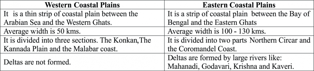
Q6. Distinguish between Western Coastal Plains and Eastern Coastal Plains.
Ans:
Q7. Distinguish between Western Ghats and Eastern Ghats.
Ans:
. eastern & western ghats_1_o.jpg)
Q8. Explain the Northern Plains of India with its divisions.
Ans: The northern plain of India is formed by three river systems, i.e. the Indus, the Ganga and the Brahmaputra; along with their tributaries. This plain is composed of alluvial soil which has been deposited over millions of years. The total area of the northern plain is about 7 lakh square kilometer. It is about 2400 km long. Width is about 240 to 320 km. Northern plains are most densely populated areas of the country. The plains are very fertile and agriculturally very productive.
The northern plain is divided into three sections, i.e. the Punjab Plains, the Ganga Plains and the Brahmaputra Plains.
(a) Punjab Plains: The Punjab plains form the western part of the northern plain. This is formed by the Indus and its tributaries; like Jhelum, Chenab, Ravi, Beas and Sutlej. A major portion of these plains is in Pakistan. Doabs are found in Punjab plains.
(b) Ganga Plains: This plain extends between Ghaggar and Tista rivers. The northern states, Haryana, Delhi, UP, Bihar, part of Jharkhand and West Bengal in the east lie in the Ganga plains.
(c) Brahmaputra Plains: This plain forms the eastern part of the northern plain and lies in Assam.
Based on the relief features; the northern plain can be divided into four regions, viz. Bhabar, Terai, Bhangar and Khadar.
(a) Bhabar: After descending from the mountains, the rivers deposit pebbles in a narrow belt. The width of this belt is about 8 to 16 kms. It lies parallel to the Shiwaliks. Bhabhar is the gently-sloping coarse alluvial zone below the Siwalik Hills (outermost foothills of Himalayas) where streams disappear into permeable sediments. The underground water level is deep in this region.
(b) Terai: The terai region lies towards south of the bhabar belt. In this region, the streams reappear and make a wet, swampy and marshy region. This region was full of forest and wildlife but after partition all this area was cleared and was converted into agricultural land for the settlement of the migrants.
(c) Bhangar: Bhangar is the largest part of the northern plain and is composed of the oldest alluvial soil. They lie above the flood plains. They resemble terraces. The soil of this region is locally known as kankar and is composed of calcareous deposits.
(d) Khadar: The floodplains formed by younger alluvium are called Khadar. The soil in this region is renewed every year and is highly fertile. This region is very suitable for intensive agricultural activities.
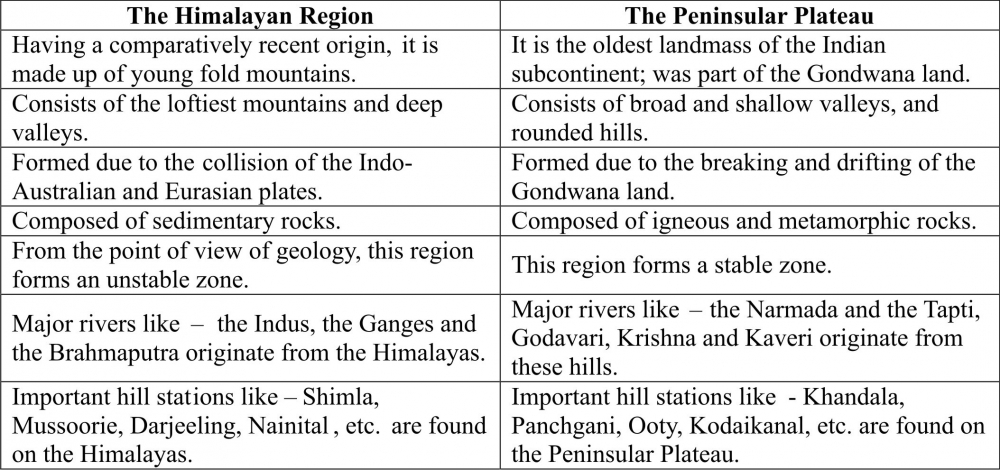
Q9. Contrast the relief of the Himalayan region with that of the Peninsular Plateau.
Ans: The following compares and contrasts between the reliefs of the Himalayan region with that of the Peninsular plateau:
Q10. Map Work: 2016-17_0_o.jpg)
-----x-----X-----x-----