Class VII: Chapter 4 (Air) Question & Answer
Very Short Answer Questions
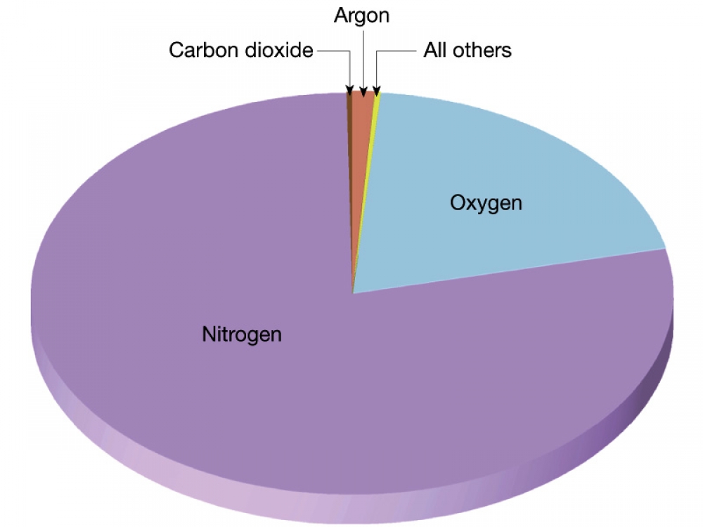
Q1. What is the composition of the air?
Ans: Atmosphere is composed of various gases. Major gases present are:
(i) Nitrogen – 78%
(ii) Oxygen – 21%
(iii) Argon - .93%
(iv) Carbon Dioxide – 0.03%
Other Gases – 0.04% (like – helium, hydrogen, methane, ozone, etc. and water vapours & dust particles.
Q2. What is normal lapse rate?
Ans: Temperature decreases at the rate of 1 degree Celsius from every 165 mtrs of ascent. This decline is known as normal lapse rate.
Q3. Define: (a) Weather (b) Climate?
Ans:
(a) Weather: The condition of atmosphere at a particular place and time is known as weather.
(b) Climate: The sum total or average of the weather conditions of a large area over a longer period of time is known as climate.
Q4. What is dew point?
Ans: Temperature at which air gets saturated is known as "Dew Point".
Q5. Which layer of the atmosphere enables wireless communications?
Ans: Thermosphere or Ionosphere is the layer of the atmosphere enables wireless communications.
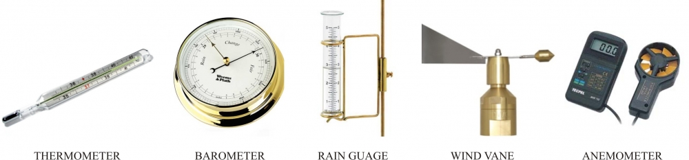
Q6. Name the unit used for measuring air pressure.
Ans: Barometer is the unit used for measuring air pressure.
Short Answer Questions
Q1. What are the factors affecting temperature of any place?
Ans. Following are the factors affecting temperature of any place:
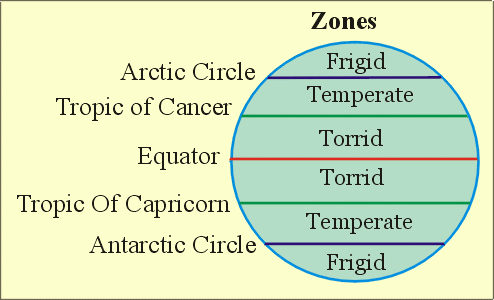
(a) Latitude or Distance From Equator.
(b) Altitude or Height Above The Sea Level
(c) Distance From The Sea
(d) Prevailing Winds and Ocean Currents
(e) Slope of Land
Q2. Why is atmosphere important for us?
Ans. Importance of atmosphere and various gases present in it are:
(a) Life giving gases like oxygen for breathing of animal kingdom and carbon dioxide is inhaled by plant kingdom.
(b) Ozone layer protects us from harmful ultraviolet rays of the sun.
(c) Tiny dust particles help in the formation of the rain droplets.
(d) It acts as a blanket which prevents the earth from becoming too hot during day and too cold during night.
(e) It protects us from falling meteors and other cosmic dusts. They burn when coming in contact with the atmosphere.
(f) Presence of gases, dust particles and water vapours lend colours to sky.
Q3. What do you mean by precipitation? What is the main source of freshwater on the earth's surface?
Ans: The process in which water vapour falls on the surface of the earth is known as precipitation. Types of precipitation: Rainfall, Snowfall, Hail, Sleet, etc. Underground water is the main source of freshwater on the earth's surface.
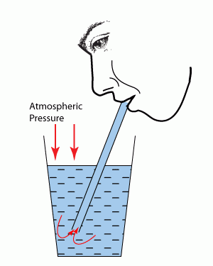
Q4. What is atmospheric pressure? How is it important to us?
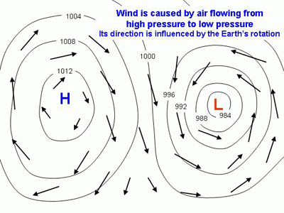
Ans: The weight of air on the earth's surface is referred to as "Atmospheric Pressure". Atmospheric Pressure is a very important element of weather and climate. A difference in the air pressure defines the direction of wind flow and accordingly, brings changes in the weather conditions.
Q5. What is the main cause of air pollution?
Ans: Any change in the composition of air is termed as "Air Pollution". Following are the main cause of air pollution:
(a) Rapid industrial growth.
(b) Excessive burning of the fossil fuels.
(c) Increase in numbers of automobiles.
(d) Burning of solid waste.
(e) Fire, etc.
Q6. Define: (a) Breeze (b) Drizzle
Ans:
(a) Breeze: These are local winds which blow only during a particular period of the day or year in a small area. For example, land and sea breeze.
(b) Drizzle: Light rainfall in the form of very tiny drop of water is called "Drizzle".
Long Answer Questions
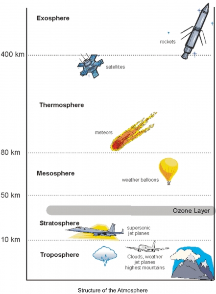
Q1. Describe the structure of the atmosphere. Draw a diagram also.
Ans. Structure of Atmosphere: Atmosphere is divided into five different layers (Troposphere, Stratosphere, Mesosphere, Ionosphere and Exosphere). It extends upto 500 kms.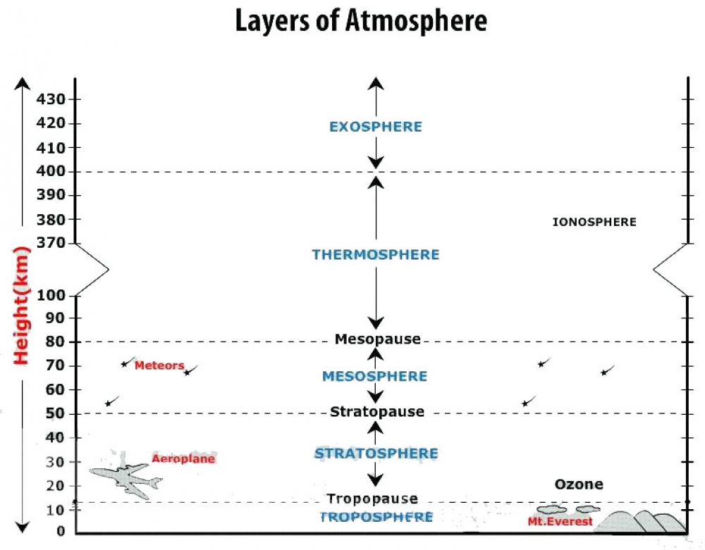
1. Troposphere:
• This layer is next to earth surface. It Extends upto 15 kms from the earth's surface.
• Temperature decreases at the rate of 1 degree Celsius from every 165 mtrs of ascent. This decline is known as normal lapse rate.
• Average height: 13 kms at poles and 18 kms over the equator.
• All weather changes take place in this layer. Oxygen exists in this layer.
• The boundary separating troposphere and stratosphere is known as tropopause.
2. Stratosphere:
• This layer is next to troposphere and it extends from 15 kms to 50 kms.
• This layer is free from weather changes, cloud formation and dust particles. Hence, this layer is ideal for the air transportation.
• Ozone layer is present here. Ozone layer absorbs/reflects the harmful ultraviolet rays of the sun.
• The boundary separating stratosphere and mesosphere is known as stratopause.
3. Mesosphere:
• This layer is next to stratosphere and it extends from 50 kms to 80 kms.
• Temperature again drops in this layer and can reach upto -100 degree Celsius at the upper boundary layer.
• The boundary separating mesosphere and ionosphere is known as mesopause.
4. Thermosphere:
• This layer is next to mesosphere and it extends from 80 kms to 400 kms.
• This layer contains electrically charged particles called ions, which are found at a height of 250 kms. Due to presence of these ions, this layer is also known as ionosphere.
• This layer protects us from the harmful radiation. Temperature increase with increase in height.
5. Exosphere:
• This is the uppermost layer above the ionosphere and it extends from 400 kms onwards and there is no end. It is a very thin layer and it merges with the space.
• This layer protects us from the harmful radiation.
• Temperature is very high. Light gases like hydrogen and helium float into space from here.
Q2. What are the different types of winds? Describe each giving examples.
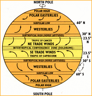
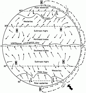
Ans. Permanent or Planetary Winds: These winds blow constantly throughout the year in a particular direction. These winds are broadly classified as: -
(a) Trade Winds
(b) Westerlies
(c) Polar Easterlies
(a) Trade Winds: These winds blow from Sub-Tropical high pressure belt towards Equatorial low pressure belt. They blow from North-East in the northern hemisphere and South-East in the southern hemisphere.
(b) Westerlies: These winds blow from Sub-Tropical high pressure belt to Sub-Polar low pressure belt.
(c) Polar Easterlies: These winds blow from Polar high pressure belt to Sub-Polar low pressure belt.
2. Seasonal or Periodic Winds: These winds change their direction in different seasons. The best example is "Monsoon Winds".
3. Local Winds: These winds blow only during a particular period of the day or year. For example, land and sea breeze. These winds bring short time changes in the weather conditions over a smaller area. Some of the examples are: -
(a) Chinook: Chinook means 'snow eater'. These winds are strong, warm and dry. They blow in North America.
(b) Loo: These are hot and dry winds which, blow during the summer season in the northern part of India.
(c) Sirocco: These are hot and moist winds, which blow from Sahara desert to Mediterranean Sea.
(b) Mistral: These are very cold winds, which blow down from the Alps over France.
Q3. Describe the different types of rainfall, Support your answer with appropriate diagram.
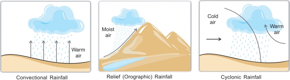
Ans. Rainfall can be classified into three types:
1. Convectional Rainfall: When hot air expands and rise to the upper layer of the atmosphere, condensation takes place which leads to formation of clouds. These clouds produce sudden and heavy rainfall. It's a daily feature in the equatorial regions.
2. Relief Rainfall: Relief rain occurs when warm air is forced to cool when it rises over a hill or mountain and then condenses. The other name for relief rain is orographic rainfall. The windward side of the mountains receives heavier rainfall in comparison to that of the leeward side (opposite) of the mountain receives little or no rain at all. It always produces a rain shadow effect.
3. Cyclonic Rainfall: When warm air mass and cold air mass meet, the warm air being lighter climbs over the cold air and cools down, leading to formation of clouds and then rainfall. This type of rain usually is due to the occurrence of cyclonic activities.

Q4. Why do places lying the windward side get rainfall while the leeward side remains dry?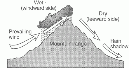
Ans: The windward side gets more rainfall than the leeward side of a mountain. This is because the prevailing winds come up and the cool air tries to hold that much moisture. But since cool air can't hold as much moisture as warm air, it begins to precipitate on the windward side (the side of mountain that is facing the prevailing winds). The dry air moves on to the leeward side (the side of a mountain that is not facing prevailing winds) and stays there, usually causing deserts to form. This makes the leeward side of the mountain have a dry climate.
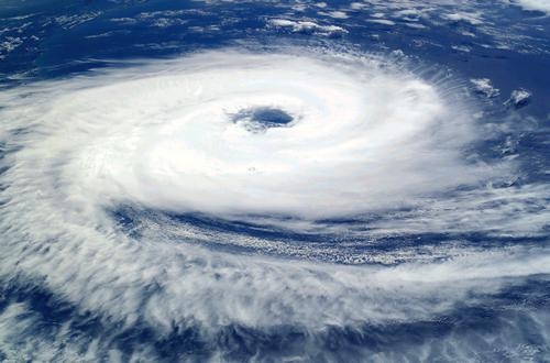
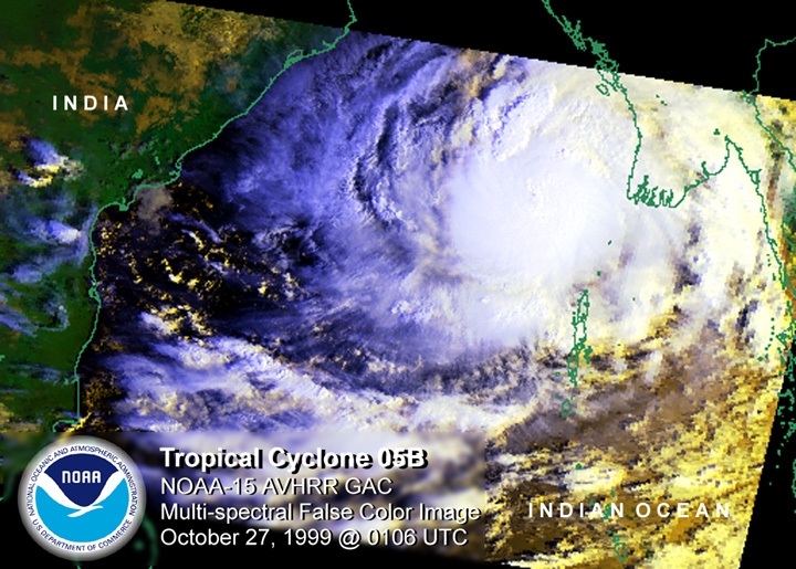
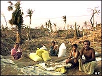
Q5. What is a cyclone? How is it different from anti cyclone?
Ans. A cyclone is a large wind system that moves around an area of low atmospheric pressure. Surrounding air moves toward the low-pressure area and starts to circulate, cyclone moves clockwise in the Southern Hemisphere and anticlockwise in the Northern Hemisphere. Cyclones can produce cloudy weather and broad areas of rain and even snow. In the United States, cyclones often are called tornadoes.
An anticyclone system has characteristics opposite to that of a cyclone. That is, an anticyclone's central air pressure is higher than that of its surroundings, and the airflow is anticlockwise in the Southern Hemisphere and clockwise in the Northern Hemisphere.
-----x-----X-----x-----
_3_o.jpg) Heating and Cooling of Atmosphere
Heating and Cooling of Atmosphere