Nirman Care - an educational blog

Class X: Chapter 1 (Resources and Development) Question & Answers

Q1. What are resources? What are their two main types?
Ans: Everything available in our environment which can be used to satisfy our needs, provided, it is technologically accessible, economically feasible and culturally acceptable can be termed as "Resource".
Resources are majorly classifies into two main types:
(a) Natural Resources: These are the free gifts of nature. For e.g. Air, Water, Soil, Sunlight, Minerals, Flora & Fauna, etc.
(b) Man Made Resources: Resources created by human beings are called Man-Made Resources. Buildings, Roads, Machines, etc

Q2. Define resources classified on the basis of Ownership of Resources.
Ans: On the basis of ownership resources are classifies into four types:
(a) Individual Resource: Resources which are owned by an individual. E.g. plot, car, house, etc.
(b) Community Resource: Resources which belongs to a community of people. E.g. parks, community halls, picnic spots, etc.
(c) National Resource: Resources which belongs to a nation. These resources are found within the political boundaries and territorial waters (i.e. ocean water upto 12 nautical miles (22.2 kms) from the coast of a country. E.g. rivers, forests, minerals, etc.
The country has legal powers to acquire private property to facilitate public.
(d) International Resource: Resources which are found beyond the territorial boundaries of a country. These resources are managed by the international institutes. No single country can use these resources without the permission of the international authorities. E.g. Minerals, fisheries, etc.

Q3. Define resources classified on the basis of Development of Resources.
Ans: On the basis of development resources are classifies into four types:
(a) Actual or Developed Resource: Resources whose existence has been proved and whose quality, quantity and location has been determined for utilization with the available technology.
(b) Potential Resource: Resources which are found in a region but have not been utilized, might be because of the lack of technology. They can be used in future. E.g. Solar and Wind are potential resource. Rajasthan and Gujarat have great potential for the development of these two resources.
(c) Reserves: Resources which can be put into use with the help of the existing technology but their use has not been started. They can be used in future. E.g. more rivers can be used for generating electricity.
(d) Stocks: Reserves which have the potential to satisfy the human needs but we don't have the technology to access it.

Q4. Write few points highlighting Rio de Janeiro Earth Summit, 1992.
Ans: Following are few points highlighting Rio de Janeiro Earth Summit, 1992:
(a) In June 1992, more than 100 heads of states met in Rio de Janeiro in Brazil, for the first International Earth Summit.
(b) The Summit was organized for addressing urgent problems of environmental protection and socio-economic development.
(c) The assembled leaders signed the Declaration on Global Climatic Change and Biological Diversity.
(d) The Rio Convention endorsed the global Forest Principles and adopted Agenda 21 for achieving Sustainable Development in the 21st century.

Q5. What are the five major factors responsible for the formation of Soil?
Ans: Following are the five major factors responsible for the formation of Soil:
(a) Relief: Altitude and slope determines the accumulation of soil.
(b) Parent Rock: It determines, colour, texture, chemical properties, mineral contents, etc.
(c) Climate: Rainfall and temperature influence rate of humus and weathering.
(d) Time: It determines thickness of soil profile.
(e) Vegetation & Other Forms of Life: Microorganisms & vegetation affect the rate of humus formation.

Q6. What do you mean by resource planning? What are its different stages?
Ans: Resource planning is the judicious use of resources. Following are the three different stages for the resource planning:
(a) Identification of resources across the country.
(b) Proper planning structure with appropriate technology, skill and institutions.
(c) Matching the resource development plans with overall development plans.

Q7. Name the different types of soils found in India. Give three main features of alluvial soil.
Ans: Soils are classified on the basis of colour, texture, fertility, mineral content, etc. Broadly, soil is classified into six types: Alluvial Soil, Black Soil, Red & Yellow Soil, Laterite Soil, Arid Soil and Forest Soil.
Alluvial soil is found in the river deltas of the eastern coast. Three main features of alluvial soil are:
(a) Alluvial soil consists of various proportions of sand, silt and clay and is the most fertile soil.
(b) Alluvial soil has adequate proportion of potash, phosphoric acid and lime which is ideal for the growth of sugarcane, paddy, wheat, etc.
(c) According to their age alluvial soil can be classified into two: Old alluvial (Bangar) and new alluvial (Khadar).

Q8. Mention atleast five steps that can be taken to control soil erosion.
Ans: Following steps can be taken to control soil erosion:
(a) Mulching: Bare ground between plants is covered with a layer of organic matter like straw. It helps to retail soil moisture.
(b) Contour Ploughing: Ploughing along contours can decrease the flow of water down the slopes.
(c) Terrace Farming: Steps can be cut out on the slopes making terrace. Terrace farming restricts erosion.
(d) Shelter Belts: Planting lines of trees to create shelter which will break the force of the wind.
(e) Strip Cropping: Strips of grass are grown between the crops. This breaks the force of wind.
(f) Rock Dam: Rocks are piled to slow the speed of wind.
(g) Afforestation, Crop Rotation, Control over Deforestation and Overgrazing, etc.

Q9. Explain land use pattern in India and why has the land under forest not increased much since 1960-61?
Ans: India has total 3.28 million square kilometer. According to the land used data records are available only for about 93% of land of total geographical area. Of the total about 46% of land is used as net sown area, 22% of is forest cover, 5% cultivable land, 8% fallow land, 4% is covered by pastures and 1% is covered by tree crops. The pattern of net sown area varies from state to state. As per National Forest Policy (1952), the forest should be 33% of total geographical area, which is essential to maintain ecological balance but in India the forest cover is only 22%.
Large scale of development, industrialization and urbanization as well as agricultural expansion has widely reduced the forest cover in various parts of the country. Though afforestation and other government policies have lead to a marginal increase in the forest cover area in the country.

Q10. How have technical and economic development led to more consumption of resources?
Ans: Human beings interact with nature through technology and create institutions to accelerate their economic development. Technical and economic development always leads to more consumption of all types of resources (i.e. natural and man-made) because of the following reasons:
(a) Technological progress makes available the knowledge to bring resources under use.
(b) With economic progress, more industries will be setup. With growth in industrialization will lead to increasing demand for all the types of resources (i.e. land, labour, capital, etc.).
(c) With technological and economic development income level of the people will increase due to which demands will increase, which will lead to more services and more consumption of resources.


-----x-----X-----x-----

Class X: Chapter 1 (Resources and Development)

Objectives and Goals:

1. Define Resources.
2. Interdependent relationship between Nature, Technology and Institution.
3. Classification of Resources.
4. Resources classified on the basis of Origin – Biotic & Abiotic.
5. Resources classified on the basis of Exhaustibility – Renewable & Non-Renewable.
6. Resources classified on the basis of Ownership – Individual, Community, National & International.
7. Resources classified on the basis of Status of Development – Potential, Developed, Stock & Reserve.
8. Development of Resources.
9. Sustainable Development.
10. Rio de Janeiro Earth Summit, 1992 and Agenda 21.
11. Resource Planning in India.
12. Conservation of Resources.
13. Land Resource, Land Utilization and Land use pattern in India.
14. Land Degradation and Conservation Measures.
15. Soil as a Resource.
16. Classification of Soil (i.e. Alluvial Soil, Black Soil, Red & Yellow Soil, Laterite Soil, Arid Soil, Forest Soil).
17. Soil Erosion and Soil Conservation.


Interdependent relationship between Nature, Technology and Institution.


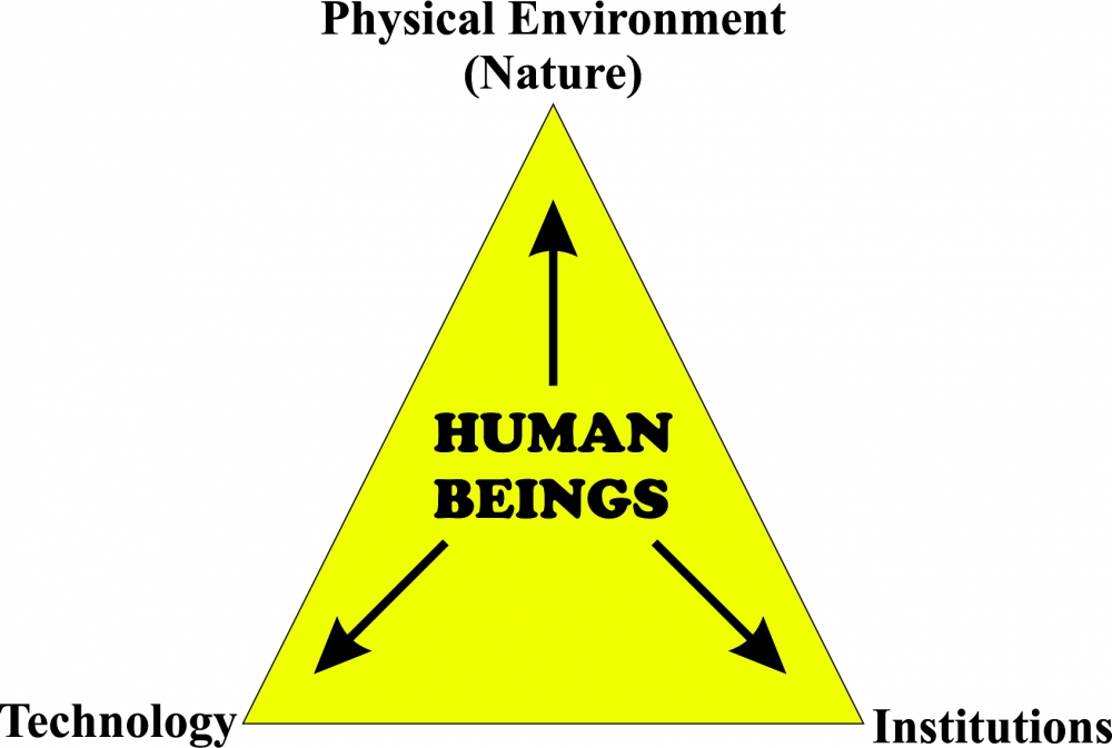
Resource: Everything available in our environment which can be used to satisfy our needs, provided, it is technologically accessible, economically feasible and culturally acceptable can be termed as "Resource".

Classification of Resources:


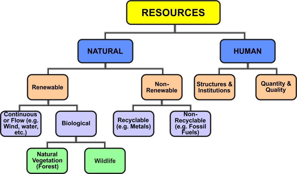
1. On the basis of Origin of Resources: (a) Biotic  (b) Abiotic
(a) Biotic Resource: All living things are known as Biotic Resources. These resources are obtained from the Biosphere and they have life, such as – Human Beings, Flora, Fauna, fisheries, etc.
(b) Abiotic Resource: All non-living things are known as Abiotic Resources, such as Wind, Water, Air, Rocks, Metals, etc.

2. On the basis of Exhaustibility of Resources: (a) Renewable  (b) Non-Renewable
(a) Renewable Resource: Resources which can be renewed or reproduced by physical, chemical or mechanical process are known as Renewable or Replenishable Resource. E.g. Solar & Wind energy, Water, etc.
Renewable resources are further classified into continuous or flow.
Many resources are replenishable which means these resources are recycled within the environment by natural process and their quantities remain constant. E.g. Oxygen Cycle and Water Cycle take place rapidly, whereas e.g. like Rock Cycle is very slow.
(b) Non-Renewable Resource: Fossil Fuels like, coal, petroleum, natural gas are the best examples of non-renewable resource. These resources are limited in supply and it takes millions of years in their formation.
Metals like Gold, Silver, Copper and Iron are recyclable.

3. On the basis of Ownership of Resources: (a) Individual  (b) Community  (c) National  (d) International

(a) Individual Resource: Resources which are owned by an individual. E.g. plot, car, house, etc.

(b) Community Resource: Resources which belongs to a community of people. E.g. parks, community halls, picnic spots, etc.

(c) National Resource: Resources which belongs to a nation. These resources are found within the political boundaries and territorial waters (i.e ocean water upto 12 nautical miles (22.2 kms) from the coast of a country. E.g. rivers, forests, minerals, etc.
The country has legal powers to acquire private property to facilitate public.

(d) International Resource: Resources which are found beyond the territorial boundaries of a country. These resources are managed by the international institutes. No single country can use these resources without the permission of the international authorities. E.g. Minerals, fisheries, etc.

4. On the basis of Distribution of Resources: (a) Ubiquitous (b) Localised

(a) Ubiquitous Resource: Resources which are found everywhere are called ubiquitous resource. E.g. air, land, water, etc.

(b) Localised Resource: Resources which are found only in certain places are localised resources, like coal, petrol, iron, etc.

5. On the basis of Stage of Development of Resources: (a) Actual or Developed Resource (b) Potential Resource
(c) Reserves (d) Stock

(a) Actual or Developed Resource: Resources whose existence has been proved and whose quality, quantity and location has been determined for utilization with the available technology.

(b) Potential Resource: Resources which are found in a region but have not been utilized, might be because of the lack of technology. They can be used in future. E.g. Solar and Wind are potential resource. Rajasthan and Gujarat have great potential for the development of these two resources.
(c) Reserves: Resources which can be put into use with the help of the existing technology but their use has not been started. They can be used in future. E.g. more rivers can be used for generating electricity.

(d) Stocks: Reserves which have the potential to satisfy the human needs but we don't have the technology to access it.

Development of Resources:
Resources are the free gifts of nature and are very important for human beings. Some of the problems faced are:
• Depletion of resources for satisfying the greed of few individuals.
• Accumulation of resources in only few hands leaves others unsatisfied.
• Unsystematic use of resources is creating many problems around the world, such as global warming, ecological crisis, disturbance in ozone layer, etc.

Sustainable Development:
Development which should takes place without damaging the environment and compromising with the needs of the future generations is called sustainable development.

Rio de Janeiro Earth Summit, 1992:
• In June 1992, more than 100 heads of states met in Rio de Janeiro in Brazil, for the first International Earth Summit.
• The Summit was organized for addressing urgent problems of environmental protection and socio-economic development.
• The assembled leaders signed the Declaration on Global Climatic Change and Biological Diversity.
• The Rio Convention endorsed the global Forest Principles and adopted Agenda 21 for achieving Sustainable Development in the 21st century.

Agenda 21:
• It aims at achieving global sustainable development.
• It is an agenda to combat environmental damage, poverty, disease through global co-operation on common interests, mutual needs and shared responsibilities.
• One major objective of the Agenda 21 is that every local government should draw its own local Agenda 21.

Resource Planning:
• Resource planning is the judicious use of resources.
• In India, resources are unevenly distributed and thus resource planning becomes very essential.
• In India, many states are rich in mineral and deficient in other resources, such as Jharkhand is rich in minerals, but there is problem of drinking water and other facilities, Arunachal Pradesh has plenty of water but lack of other development because of lack of resources.
• These types of discriminations can be reduced or completely eradicated with proper planning of judicious use of resources.

Resource Planning in India:
• In order to get the maximum output, a good resources planning is must keeping in mind the technology, skills and institutions.
• Since independence "Five Year Plans" have played a vital role in planning and development of the resources.

Following are the main points of Resource planning.
(a) Identification of resources across the country.
(b) Proper planning structure with appropriate technology, skill and institutions.
(c) Matching the resource development plans with overall development plans.

Conservation of Resources:
• Irrational consumption and over-utilization of resources have lead to socio-economic and environmental problems.
• Judicious use and conservation of resources is must. Gandhiji told "There is enough for everybody's need and not for any body's greed." He thought that exploitative nature of modern technology is the root cause for depletion at global level. He believed in the production by masses and not in the mass production.

Land Resources:
• Land is one of the most important natural resources.
• Land supports our life system with the basic necessities of life (i.e. food, cloth and shelter). Thus, proper planning is must for the proper utilization of land as a resource.
• Land is not even everywhere, India comprises of many types of land forms (i.e mountains, plateau, plains and islands).

Plain: About 43% of land area in India is in the form of plains. Plains provide facilities for agriculture, building of industries and houses, etc.
Mountains: About 30% of land area in India is in the form of mountain. Mountain supports the perennial flow of rivers, which carry fertile soils, facilitate irrigation and provide drinking water.
Plateau: About 27% of land in India is in the form of plateau which provides many types of minerals, fossil fuels and forest.

Land Utilization:
Land Resources are used for following purposes:
1. Forests
2. Land not available for cultivation:
(a) Barren and waste land.
(b) Lands used for buildings, roads, factories, etc. (i.e. for non-agriculture purpose).
3. Other Uncultivated Land (excluding fallow land):
(a) Permanent pastures and grazing land.
(b) Land under miscellaneous tree crops groves (not included in net sown area).
(c) Cultruable waste land (left uncultivated for more than 5 agricultural years).
4. Fallow Lands:
(a) Current fallow-(left without cultivation for one or less than one agricultural year).
(b) Other than current fallow-(left uncultivated for the past 1 to 5 agricultural years).
5. Net Sown Area: Area which is sown at least once in a year is called net sown area.
6. Gross Cropped Area: Area sown more than once in an agricultural year plus net sown area is known as gross cropped area.

Land Use Pattern in India:
• Pattern of use of land depends upon physical and human factors both.
• Climate, topography, type of soil, etc. are considered as physical factors.
• While population, technology, skill, population density, tradition, capability, etc. are considered as human factors.
• India has total 3.28 million square kilometer land used data. But only 93% of land of total geographical area is available. This is because land used data has not been collected for the north eastern states except Assam and the land occupied by Pakistan and China has not been surveyed because of many unavoidable reasons.
• The land under permanent pasture is decreasing; this will create the problem for grazing.
• The total net sown area (NSA) is not more than 54% including land other than fallow land.
• Land other than fallow land is either of poor quality or too costly to cultivate, these lands are cultivated only once or twice in two or three consecutive years.
• The pattern of net sown area varies widely from state to state. Where net sown area is 80% in state like Punjab, it is only 10% in the state of Arunachal Pradesh, Mizoram, Manipur and Andaman and Nicobar Island. Such difference is creating lot of discrimination.
• According to National Forest Policy (1952), the forest should be 33% of total geographical area, which is essential to maintain ecological balance. But the forest area in India is far less than desired measures. This is because of illegal deforestation and development which cannot be overlooked, such as construction of roads and building, etc.
• On the other hand, a large population which is dwelling at the edge of forest depends upon the forest and its produce, resulting in the reduction of forest area.
• Moreover, continuous use of land over a long period without taking measures to conserve and manage, degrade them. This has led to serious problem to environment.

Land Degradation & Conservation
• Land is limited but the demand is increasing everyday.
• The change in land use pattern shows the changes in the society.
• Land Degradation: It is the decline in the productive capacity of land for some time or permanently.
• Most of our basic needs (i.e. food, clothing & shelter) is obtained from land.
• But in past few decades the quality of land is degrading fiercely because of human activity.
• Presently, about 130 million hectare of land is reported under degraded land in India.
• Approximately, 28% of land belongs to forest degraded area.
• 56% is water eroded land area.
• Rest degraded land is because of over deposition of salinity and alkalinity.
• Overgrazing, mining, deforestation, division of lands in small area because of family disputes, etc. are some of the major causes of degradation of land.
• In the states of Jharkhand, Chhattisgarh, Orissa and Madhya Pradesh along with mining, deforestation in these states has degraded the land very fast.
• In the states of Gujarat, Rajasthan, Madhya Pradesh, Maharashtra overgrazing is the major cause of land degradation.
• In the states of Uttar Pradesh, Punjab, Haryana, over irrigation causes water shortage and increase in salinity and alkalinity due to water logging.
• In Bihar, Assam, Arunachal Pradesh, land is degraded because of flood.
• The degradation of land creates many problems, such as flood, decrease in yield, etc. which leads to decrease in GDP and country has to face economic problems.

Land Degradation & Conservation
Common causes of land degradation are:
1. Deforestation
2. Overgrazing
3. Urbanization
4. Industrialization
5. Dumping of Chemical Wastes
6. Excessive use of Fertilizers
7. Bad Farming Techniques

Some of the measures to control land degradation are:
1. Constructing retention walls in the mountain areas to stop landslides.
2. Land Reclamation (i.e. Proper management of waste lands)
3. Regulated use of chemical fertilizers and pesticides
4. Afforestation
5. Check on Overgrazing
6. Control of Mining Activities
7. By proper irrigation.
8. By proper harvesting.
9. Discharge of industrial waste and effluents only after proper treatment.
10. By preventing the deforestation.


SOIL

• The uppermost or topmost layer of the earth's crust is known as soil. It is the loose material consisting of organic and inorganic substances.
(Humus is a dark coloured stable form of organic matter that remains after most of plant or animals residues have decomposed).
• Most of the food items like wheat, rice, pulses, fruits, vegetables, etc. are obtained from plants that grow on soil. Soil provides food, cloth and shelter, etc.

Factors of Soil Formation:
1. Relief: Altitude and slope determines the accumulation of soil.
2. Parent Rock: It determines, colour, texture, chemical properties, mineral contents, etc.
3. Climate: Rainfall and temperature influence rate of humus and weathering.
4. Time: It determines thickness of soil profile.
5. Organisms: Microorganisms & vegetation affect the rate of humus formation.

Soil Profile:

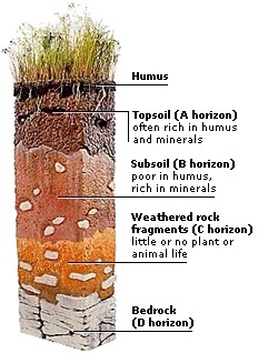
Soil profile refers to the different layers of the soil. There are four different layers:
1. Top soil
2. Sub Soil
3. Weathered Rock
4. Bed Rock or Parent Rock

1. Top Soil:
• It is the uppermost layer.
• Rich in humus and minerals.
• Consists of Sand, Silt & Clay.

2. Sub Soil:
• It lies below the top soil and supports moisture.
• Consists of weathered rock, Silt & Clay and some nutrients.

3. Weathered Rock

4. Bed Rock:
• Consists of solid layer of unweathered Rock.

Classification of Soil:

Soils are classified on the basis of colour, texture, fertility, mineral content, etc. Broadly, soil is classified into six types: -
1. Alluvial Soil
2. Black Soil
3. Red & Yellow Soil
4. Laterite Soil
5. Arid Soil
6. Forest Soil

1. Alluvial Soil:
• It is the most important and most fertile type of soil found in India covering about 40 per cent of the total land area.
• Soil is formed by the deposition of sediments brought down by the rivers.
• The alluvial soil is found mostly in the Northern Plains and Coastal Plains of India (Particularly deltas of Mahanadi, Godavari, Krishna and Kaveri).
• The fine particles of sand, silt and clay are called alluvium. The alluvial soil can be divided into old alluvium, also called Bangar, and new alluvium, called Khadar.
• Alluvial soil has adequate proportion of potash, phosphoric acid and lime which is ideal for the growth of sugarcane, paddy, wheat, etc.
• Regions of Alluvial soil are intensively cultivated and are densely populated.

2. Black Soil:
• The black soil is also called the Regur Soil or the Black Cotton Soil. Cotton grows best in this soil.
• Black soil is formed from the weathering of the igneous rocks.
• The black soil is mostly found in the Deccan Trap, covering large areas of Maharashtra, Chhattisgarh, Gujarat and Madhya Pradesh. It is also found in some parts of Godavari and Krishna river valleys, covering parts of Karnataka, Andhra Pradesh and Tamil Nadu.
• Black soil has high concentration of fine particles and thus can hold moisture for long time.
• It contains calcium carbonate, potassium, magnesium and lime.
• This soil is poor in phosphoric contents.

3. Red & Yellow Soil:
• Red soil is derived from the weathering of the igneous and metamorphic rocks. It is found in the areas of low rainfall.
• The red colour is due to the high percentage of iron contents.
• Red & Yellow soils are found in the parts of Odisha, Chhattisgarh Ganga plain and Western Ghats. It is also found in the southern and eastern parts of the peninsular plateau.

4. Laterite Soil:
• Laterite has been derived from a Latin word called "Later" which means Brick.
• The laterite soil is widely spread areas with high temperature and rainfall. This causes leaching of the soil and microorganisms are killed during the process.
• This soil is mainly found in Kerala, Karnataka, Tamil Nadu, Madhya Pradesh and in hilly areas of Orissa and Assam.
• Due to intensive leaching, the laterite soil generally lacks fertility and is of low value for crop production. But when manured and timely irrigated, the soil is suitable for producing plantation crops like tea, coffee, rubber, coconut, etc.

Leaching is a process in which heavy rains wash away the fertile part of the soil.

5. Forest Soil:
• The Forest soil is generally found on the hill slopes covered with forests.
• This type of soil is found in the Himalayan region, the Western and Eastern Ghats and in some parts of the Peninsular India.
• Soil is loamy and silty in valley sides and coarse grained in the upper slopes.
• This soil is rich in humus, but poor in potash, phosphorus and lime.
• This soil is especially suitable for producing plantation crops, such as tea, coffee.

6. Arid Soil:
• The Arid soil is found mostly in the arid and semi-arid regions, receiving less than 50 cm of annual rainfall.
• Soil colour ranges from red to brown.
• Sandy in texture and saline in nature.
• Soil lacks in humus and moisture.
• The lower layer of the soil is occupied by Kankar because of increasing calcium content downwards.
• Such regions are mostly found in Rajasthan and the adjoining areas of Haryana and Punjab. The Rann of Kachchh in Gujarat is an extension of this region.
• The desert soil has sand (90 to 95 per cent) and clay (5 to 10 per cent).


SOIL EROSION AND SOIL CONSERVATION
• The denudation of the soil cover and subsequent washing down is described as soil erosion.
Or
• Removal of top soil is called soil erosion.
• The running water cuts through the clayey soil and makes deep channels known as Gullies.
• The land becomes unfit for cultivation and is known as Bad Land.

DEGRADATION OF SOIL
• Soil erosion is the degradation of soil by human activities.
• Following are the factors responsible for the soil erosion: -
1. Deforestation
2. Overgrazing
3. Construction
4. Overuse of Chemical Fertilizers
5. Pesticides
6. Natural Calamities (Flood, landslides, etc.)

CONSERVATION OF SOIL
• Soil conservation means protection, preservation and proper utilization of the soil.
• Some methods of soil conservation are: -

1. Mulching: Bare ground between plants is covered with a layer of organic matter like straw. It helps to retail soil moisture.
2. Contour Ploughing: Ploughing along contours can decrease the flow of water down the slopes.
3. Terrace Cultivation: Steps can be cut out on the slopes making terraces.

4. Strip Cropping: Strips of grass are grown between the crops. This breaks the force of wind.

5. Shelter Belts: Rows of trees are planted to create shelter. Thus, the speed of wind is reduced.
6. Rock Dam: Rocks are piled to slow the speed of wind.
7. Contour Barriers: Stones, grass, soil are used to make barriers. Trenches are made in front of the barriers to collect water.
8. Afforestation, Crop Rotation, Control over Deforestation and Overgrazing, etc.


-----x-----X-----x-----

Class X: Map Work for Practice

A. HISTORY:

Outline Political Map of India


Lesson-3 Nationalism in India – (1918 – 1930)
For locating and labeling / Identification.

1. Indian National Congress Sessions:
(a) Calcutta (Sep. 1920)
(b) Nagpur (Dec. 1920)
(c) Madras (1927)
(d) Lahore (1929)

2. Important Centres of Indian National Movement:
(Non-Cooperation and Civil Disobedience Movement)
(a) Champaran (Bihar) - Movement of Indigo Planters
(b) Kheda (Gujarat) - Peasant Satyagrah
(c) Ahmedabad (Gujarat) - Cotton Mill Workers Satyagraha
(d) Amritsar (Punjab) - Jallianwala Bagh Incident
(e) Chauri Chaura (Uttar Pradesh) - Calling off the Non Cooperation Movement
(f) Dandi (Gujarat) - Civil Disobedience Movement


B.GEOGRAPHY
Outline Political Map of India


Chapter 1: Resources and Development
Identification only:

Major soil Types.


Chapter 3: Water Resources
Locating and Labeling:

Dams:
(a) Salal

(b) Bhakra Nangal

(c) Tehri

(d) Rana Pratap Sagar

(e) Sardar Sarovar

(f) Hirakud

(g) Nagarjuna Sagar

(h) Tungabhadra. (Along with rivers)


Chapter 4: Agriculture
Identification only

(a) Major areas of Rice and Wheat.
(b) Largest / Major producer states of Sugarcane; Tea; Coffee; Rubber; Cotton and Jute.


Chapter: 5 Mineral and Energy Resources. Minerals
(Identification only)

(a) Iron Ore Mines: Mayurbhanj, Durg, Bailadila, Bellary, Kudremukh
(b) Mica Mines: Ajmer, Beawar, Nellore, Gaya, Hazaribagh
(c) Coal Mines: Raniganj, Jharia, Bokaro, Talcher, Korba, Singrauli, Singareni, Neyvali.
(d) Oil Fields: Digboi, Naharkatia, Mumbai, High Bassien Kalol, Ankaleshwar
(e) Bauxite Deposits: The Amarkantak plateau, Maikal hills, The plateau region of Bilaspur- Katni and Orissa Panchpatmali deposits in Koraput district.
(f) Mica Deposits: The Chota Nagpur plateau, Koderma Gaya – Hazaribagh belt of Jharkhand, Ajmer & Nellore mica belt

Power Plants:
(Locating and Labeling only)

(a) Thermal: Namrup, Talcher, Singrauli, Harduaganj, Korba, Uran, Ramagundam, Vijaywada & Tuticorin

(b) Nuclear: Narora, Rawat Bhata, Kakrapara, Tarapur, Kaiga & Kalpakkam


Chapter 6: Manufacturing Industries
(Locating and Labeling Only)

(a) Cotton Textile Industries: Mumbai, Indore, Ahmedabad, Surat, Kanpur, Coimbatore & Madurai.
(b) Iron and Steel Plants: Burnpur, Durgapur, Bokaro, Jamshedpur, Raurkela, Bhilai, Vijaynagar, Bhadravati, Vishakhapatnam & Salem

(c) Software Technology Parks: Mohali, Noida, Jaipur, Gandhinagar, Indore, Mumbai, Pune, Kolkata, Bhubaneshwar, Vishakhapatnam, Hyderabad, Bangalore, Mysore, Chennai & Thiruvanantapuram


Chapter 7 Lifelines of National Economy

Identification Only:

Golden Quadrilateral, North-South Corridor, East-West Corridor.

(a) National Highways: NH-1, NH-2 & NH-7

Locating and Labeling:
(b) Major Ports: Kandla, Mumbai, Jawahar Lal Nehru, Marmagao, New Mangalore, Kochi, Tuticorin, Chennai, Vishakhapatnam, Paradip, Haldia & Kolkata.

(c) International Airports: Amritsar (Raja Sansi), Delhi (Indira Gandhi International), Mumbai (Chhatrapati Shivaji), Thiruvanantapuram (Nedimbacherry), Chennai (Meenam Bakkam), Kolkata (Netaji Subhash Chandra Bose), Hyderabad (Rajiv Gandhi)


Note: Items of Locating and Labeling may also be given for Identification.


-----x-----X-----x-----

Class X (Full Syllabus): More Questions for Revision

CHAPTER 1 (RESOURCES AND DEVELOPMENT)

Answer the following questions: Total Marks - 50

Q1. What is a Fallow Land? 1
Q2. What is Sub Soil? 1
Q3. Define Marginal Land. 1
Q4. Which term is used to identify the old and new alluvial respectively? 1
Q5. How much percentage of forest area should be there in the country according to the National Forest Policy? 1
Q6. Which type of soil develops due to high temperature and evaporation? 1
Q7. What is Leaching? 1
Q8. What steps can be taken to control soil erosion in hilly areas? 3
Q9. When and why was the Rio-de-Janeiro Earth Summit held? 3
Q10. "Net Sown Area varies from place to place". Why? 3
Q11. Distinguish between potential resources and stock with the help of examples. 3
Q12. Write any three problems associated with the indiscriminate use of resources by the human beings. 3
Q13. Distinguish between resources on the basis of Exhaustibility of Resources. 3
Q14. Explain land use pattern in India and why the land under forest has not increased much since 1960-61. 5
Q15. How have technological and economic development led to more consumption of resources? 5
Q16. What are the steps involved in the complex process of resource planning? Why is resource planning important in the context of a country like India? 5
Q17. What does the term "Land Degradation" mean? Which human activities have contributed significantly in land degradation? Suggest measures to solve the problem of land degradation. 5
Q18. Define any five major characteristics of "Arid Soil". 5

-----x-----X-----x-----


CHAPTER 3 (WATER RESOURCES)

Answer the following questions: Total Marks - 50

Q1. Which river is known as "River of Sorrow"? 1
Q2. In the eleventh century which was the largest artificial lake built? 1
Q3. Name the king (Sultan) who built the tank in Hauz Khas, Delhi for supplying water to Siri Fort area.1
Q4. What is the major source of freshwater in India? 1
Q5. On which river Koyna Dam is built? 1
Q6. What is the rank of India in the world in term of availability of water per person per annum? 1
Q7. Globally, how much amount of precipitation is received by India? 1
Q8. What are the objectives of rainwater harvesting? State any three. 3
Q9. What are the ill-effects of irrigation? How is it responsible for transforming social landscape? 3
Q10. Why is conservation and management of water resources important? Give any three reasons. 3
Q11. Mention three major sources if irrigation in India. Which source of irrigation is most popular in southern India and why? 3
Q12. Highlight any three key features of the Narmada Bachao Andolan. 3
Q13. State any three examples (other than roof top rainwater harvesting) of traditional water harvesting system prevalent in various parts of India. 3
Q14. Multipurpose river projects are referred as the "Temples of modern India". Elucidate. 5
Q15. What is water scarcity? Give any four reasons to specify why there is scarcity of water across the globe? 5
Q16. What are interstate water disputes? Why are such issues raised? Give any three examples of interstate water disputes. 5
Q17. In the recent years, multipurpose river dam projects and large dams have come under great scrutiny and opposition. Explain. 5
Q18. Usage of tankas is very common in Rajasthan. Mention some of the features of these 'tankas' built in the houses of Bikaner and Phalodi. 5

-----x-----X-----x-----


CHAPTER 4 (AGRICULTURE)

Answer the following questions: Total Marks - 50

Q1. What is Bhoodan – Gramdan movement? 1
Q2. Name any two beverage crops produced in India. 1
Q3. Mention different names by which slash and burn type of farming is known in India along with the name of the states. 1
Q4. In the states like Assam, Odisha and West Bengal, three crops of paddy are grown, name the crops. 1
Q5. Name the major maize producing states in India. 1
Q6. Which type of crop is known as "Leguminous Crop"? 1
Q7. In the first five year plan the main focus was on what? 1
Q8. Mention the factors which have influenced the change in the methods of cultivation. 3
Q9. What are coarse grains? Describe their characteristics. 3
Q10. Describe the geographical conditions, and major sugarcane producing states of India. 3
Q11. Distinguish between Rabi and Kharif season. 3
Q12. Mention any three geographical conditions required for the growth of Wheat in India. 3
Q13. Distinguish between subsistence farming and commercial farming. 3
Q14. What is plantation agriculture? Write its four characteristics. 5
Q15. Name any two fiber crops produced in India. Describe any two geographical conditions required for the growth of each crop. 5
Q16. Explain the challenges faced by Indian agriculture. 5
Q17. Mention important technological and institutional reforms introduced in India after independence in the 1960s and 1970s. 5
Q18. What is Horticulture? Name the fruits grown in India. Mention the name of states also. 5

-----x-----X-----x-----


CHAPTER 5 (MINERALS AND ENERGY RESOURCES)

Answer the following questions: Total Marks - 50

Q1. In the recent years, use of which fuel for transport vehicles is gaining popularity? 1
Q2. Where was petroleum drilled first in India? 1
Q3. What is "Rat Hole Mining"? 1
Q4. Name the two leading copper producing states of India. 1
Q5. What are Veins and Lodes? 1
Q6. What is a "Mine"? 1
Q7. What are placer deposits? 1
Q8. "Solar energy has a bright future in India". Support the statement with three facts. 3
Q9. What are the uses of limestone? Mention the states which are the major producers of limestone? 3
Q10. How is mica one of the most indispensable minerals? Explain any three points. 3
Q11. What are the differences between hydro-electricity and thermal electricity? 3
Q12. Draw a flow chart to explain the classification of minerals. 3
Q13. "Energy saved is energy produced". Justify the statement by giving any three measures to conserve the energy resources. 3
Q14. What is an ore? Explain the distribution of iron ore in India. 5
Q15. Explain different modes where minerals occur. 5
Q16. Differentiate between conventional and non-conventional sources of energy. 5
Q17. Name the ore from which aluminium is extracted. State any four uses of aluminium. Name two states where its ore is found. 5
Q18. What is the most abundantly available fossil fuel in India? What are its three major forms? Write the main features of each form. 5

-----x-----X-----x-----


CHAPTER 6 (MANUFACTURING INDUSTRIES)

Answer the following questions: Total Marks - 50

Q1. Which industry has been a major foreign exchange earner in the last few years? 1
Q2. When and where was the first successful cotton textile industry setup in India? 1
Q3. What is the objective of NMCC? 1
Q4. What is the full form of BPO? 1
Q5. What is a consumer industry? 1
Q6. When and where was the first jute mill set up in India? 1
Q7. Dyeing, Spinning, Garment Manufacture, Fiber Production, Weaving. Arrange the activities from the start till the end. 1
Q8. Why did the traditional cotton textile industry of India receive a setback during the colonial period? 3
Q9. Explain three phases by which treatment of industrial effluents can be done. 3
Q10. Enlist various factors upon which growth of modern industry depends. 3
Q11. What are software technology parks ? State any two points of significance of Information Technology industry in India ? 3
Q12. Distinguish between an integrated steel plant and a mini steel plants stating three points of distinction. 3
Q13. Mention any two factors that have contributed to a healthy growth of the automobile industry in India. Name two centers where this industry is located. 3
Q14. Why does the north-eastern part of the Peninsular Plateau region have the maximum concentration of iron and steel industries? 5
Q15. What is the importance of the manufacturing industries? 5
Q16. Name the different types of pollution caused by industries. Explain each with appropriate example. 5
Q17. Which factors are responsible for shifting of sugar mills to southern and western states? Mention the challenges faced by the industry. 5
Q18. Draw a flow chart to explain the classification of industries. 5

-----x-----X-----x-----


CHAPTER 7 (LIFELINES OF NATIONAL ECONOMY)

Answer the following questions: Total Marks - 50

Q1. Which state has the highest density of roads in India? 1
Q2. Name the oldest artificial port in India? 1
Q3. What are rural roads? 1
Q4. Name the six mail channels that have been introduced by the Indian Postal Department. 1
Q5. Which port in India is known as the tidal port? 1
Q6. In India, first train ran between which two stations, in which year and covered an area of how many kilometers? 1
Q7. Name the different types of roads classified on the basis of the type of material used. 1
Q8. Which is the cheapest means of transportation? Write its three advantages. 3
Q9. Distinguish between Personal Communication and Mass Communication. 3
Q10. Mention the names of three National Waterways in India. 3
Q11. What is the length of coastline of India? What is Paradwip famous for, and in which state is it situated? 3
Q12. Distinguish between National Highways and State Highways. 3
Q13. Define balance of trade. Distinguish between favourable balance of trade and unfavourable balance of trade. 3
Q14. What are Golden Quadrilateral Super Highways? Mention any two objects of this project. The North – South and East – West Corridors join which terminal cities? 5
Q15. Name the important networks of pipeline transportation in India. Highlight any three merits of pipeline transport in India. 5
Q16.How do physical and economic factors influence the distribution pattern of Indian railways network? Explain with suitable examples. 5
Q17.Describe the significance of air transport. Write its two merits and two demerits. 5
Q18.Explain any five reasons why a dense and efficient network of transport and communication is a pre-requisite for trade of today. 5


-----x-----X-----x-----

Class X: Extra Questions for Practice

Q1. Describe any one feature of Golden Quadrilateral Super Highway. (1)
Q2. When was National Forest Policy implemented? What percentage of forest cover is essential to maintain ecological balance? (1)
Q3. What is Palar Pani"? (1)
Q4. What is Agglomeration Economies? (1)
Q5. What are Guls & Kuls? (1)
Q6. Define National Waterway No -2. (1)
Q7. Name some of the tools used for primitive subsistence farming in India. (1)
Q8. Define National Waterway No - 5. (1)
Q9. Which crop is known as Golden Fiber? Mention some of its uses. (1)
Q10. What is the size of Tankas in Phalodi? (1)
Q11. What is the significance of Border Roads? (3)
Q12. Suggest three physical and three human factors for the location on the industry. (3)
Q13. "Roadways still have an edge over railways in India". Support the statement with arguments. (3)
Q14. Explain any three challenges faced by sugar industry in India. (3)
Q15. Why mining is called a killer industry? (3)
Q16. What do you know about Helicopter services in India? For which purposes is it used? (3)
Q17. Why is the construction of multi-purpose dam projects and large dams opposed by many people? (3)
Q18. What are millets? Give two examples and areas they are grown in. (3)
Q19. Mention the varieties of coal found in India. (3)
Q20. Highlight some of the key points of the India Postal Service. (3)
Q21. Differentiate between Conventional and non-conventional sources of energy. (3)
Q22. What are resources? What are their two main types? (3)
Q23. Which is the next major source of energy after coal in India? Mention any two point of its importance. (3)
Q24. What are software technology parks? State any two points of significance of Information Technology industry in India? (3)
Q25. What is Golden Quadrilateral? Name the Northern, Southern, Eastern and Westernmost stations of Golden Quadrilateral Super Highway Project. (3)
Q26. Discuss steps to be taken to minimize environmental degradation by industry. (3)
Q27. Name the ore from which aluminium is obtained. Why is aluminium considered to be an important metal? Name the areas which have rich deposits of the ore of aluminium. (5)
Q28. Write any five features of comprehensive land development programme initiated during 1980s and 1990s. (5)
Q29. What are the main types of soil found in India? Which type of soil is the most widespread and important soil of India? Describe in detail about this soil type. (5)
Q30. What is water scarcity? An area or region may have ample water resources but still face water scarcity. Explain why such circumstances arise. (5)
Q31. Describe the geographical conditions required for the cultivation of cotton in India. (5)
Q32. Describe the characteristics and distribution of iron and steel industries in India. (5)
Q33. What are the five major factors responsible for the formation of Soil? (5)
Q34. Compare the advantages and disadvantages of multi-purpose river projects. (5)
Q35. Classify roads of India into different types. (5)
Q36. What type of soil is found in the river deltas of the eastern coast? Give any four main features of this type of soil. (5)
Q37. Minerals are essential part of our life, it is important to know about the occurrence of minerals. Mention different modes where minerals occur? (5)
Q38. Explain any five reasons responsible for water scarcity in India? (5)
Q39. What is soil erosion? Mention two types of soil erosion. Suggest any three measures to check soil erosion. (5)
Q40. Describe the modern adaptations of traditional rainwater harvesting methods are being carried out to conserve and store water. (5)
Q41. Suggest the initiative taken by the government to ensure the increase in agricultural production. (5)
Q42. Why do you think that solar energy has a bright future in India? (5)


-----x-----X-----x-----

Class X: Chapter 7 (Lifelines of National Economy) Extra Questions

Q1. What are considered as the lifelines of national economy?
Q2. Name the classification of roads.
Q3. Name the different organizations responsible for the construction and upkeep of different types of roads located in India.
Q4. Name the classification of roads on the basis of the type of material used.
Q5. What is Road Density?
Q6. What are the major problems faced by Indian Roads?
Q7. Write a note on the first train of India.
Q8. Name the different rail gauge found in India.
Q9. In how many zones Indian railways have been divided?
Q10. What are the major problems faced by Indian Railways?
Q11. Name the three important networks of pipeline transportation in India.
Q12. Highlight any five key features of waterways.
Q13. How many waterways have been declared as the national waterways by the government of India? Name them.
Q14. There are how many major and minor sea ports in India?
Q15. Which was the first port developed soon after independence?
Q16. What is the total length of coastline in India?
Q17. Name the different sea ports of India used for exporting iron ore to different parts of the world.
Q18. When was the air transportation nationalized in India?
Q19. Name few of the airlines operating in India.
Q20. Highlight important airports in India.
Q21. Name the six mail channels that have been introduced recently for the quick delivery of mails in large towns and cities in India.
Q22. Highlight major means of Personal communication and mass communication in the country.
Q23. Mention key features of the Indian Postal Service.
Q24. Write a short note on All India Radio (Akashwani) and Doordarshan.
Q25. Describe the role of newspapers in India.
Q26. What is international trade?
Q27. Define: (a) Import (b) Export (c) Balance of Trade
Q28. Write a note on tourism in India.
Q29. Which industry in India has emerged in last fifteen years?
Q30. What are the two main components of international trade?


-----x-----X-----x-----

Newer posts → Home ← Older posts